Fernando de Noronha archipelago (Rio Grande do Norte Brazil)

Fernando de Noronha archipelago (Rio Grande do Norte Brazil)

To precisely geolocate this site. Update if necessary.

Localisation

Fernando de Noronha archipelago (Rio Grande do Norte Brazil)
LatitudeLongitude
DMS------
DM------
DD------

Characteristics

Coast
Natural Park

Description

Fernando de Noronha is an archipelago of 21 islands and islets in the Atlantic Ocean, 354 km offshore from the brazilian coast. The archipelago got its name from the Portuguese merchant Fernão de Loronha, to whom it was given by the Portuguese crown for services rendered regarding wood imported from Brazil.
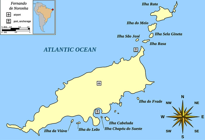
It is a nationa maritime park. In 2001 UNESCO designated it as a World Heritage Site because of the importance of its environment.

The islands of this archipelago are the visible parts of a range of submerged mountains. It consists of 21 islands, islets and rocks of volcanic origin. The main island has an area of 18 km2 (6.9 sq mi), being 10 km (6.2 mi) long and 3.5 km (2.2 mi) wide at its maximum. The base of this enormous volcanic formation is 756 metres (2,480 ft) below the surface.
The main island, from which the group gets its name, makes up 91% of the total area; the islands of Rata, Sela Gineta, Cabeluda and São José, together with the islets of Leão and Viúva make up the rest. The central upland of the main island is called the Quixaba.

The life above and below sea is the main attraction of the island. Sea turtles, dolphins, albatrosses and many other species are frequently observed.
2016/01/12
Update
Joëlle
Fernando de Noronha archipelago (Rio Grande do Norte Brazil)
Fernando de Noronha
2016-01-12
Update
Anonymous
L'archipel a été découvert en 1500 par le navigateur portugais Gaspar de Lemos, Elle est un exemple de préservation de l'environnement  et possède le statut de Parc Naturel.

Il est aussi sur la liste du Patrimoine Mondial de l'Unesco.

2016/01/12
Update
Joëlle
Ebook

NE Brazil

  • 27 sites
  • 33 photos
  • publication date: 7 Jul 2023
  • .pdf file size: 11 Mb
Share your comments or photos on "Fernando de Noronha archipelago (Rio Grande do Norte Brazil)"

Sites around Fernando de Noronha archipelago (Rio Grande do Norte Brazil)

Flying distances - Direct line

Bahia de Santo Antonio (F de Noronha N Brazil)

1.4nm
54°
It is a natural anchorage place, just off the breakwater, which provides protection for the dinghy when landing. However, this anchorage is reported to be rolly. In the winter months (July) the seas here are generally calm.
A stone pier was built for tieing up small ships. Bigger ...
12 Jan 16
Joëlle

Reserva Biológica Atol das Rocas

82nm
269°
The coral atoll is built on the upper, western part of the flat top of a volcanic seamount on the north east part of the Brazilian continental margin. The seamount rises to a depth of 30 to 15 metres (98 to 49 ft) below the surface. The distance from the reef ...
21 Feb 21
azerty

Cabo de Sao Roque (Rio Grande do Norte)

196nm
239°
sandy point, about 55m high, with vegetation on its summit. It is closest to the continent of Africa. It also marks the separation of French Guiana (where the coast is low and swampy) and the State of Rio Grande do Norte that offers to S, a massive coast with many coves and bays.

Finally, ...
6 Apr 15
Joëlle

Iate Clube do Natal (Rio Grande do Norte Brazil)

202nm
235°
The Iate Clube do Natal marina is in the town of Monsenhor Gil (Brazil).

Visiting yachtsmen welcomed. Good general repair facilities. Water, showers (cold water), bar and restaurant. (Pool & recreational facilities not open to visitors). Wifi and laundry services available. ...
13 Jan 16
Joëlle

Porto do Natal (Rio Grande do Norte Brazil)

202nm
235°
The port of Natal is situated at the mouth of the Rio Pontengi. The river flows into the sea through an opening in the barrier reef. The barrier reef forms a natural breakwater for the port.
The prevailing winds most of the year are from the ENE to SE.Formalities can be carried ...
13 Jan 16
Joëlle