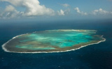
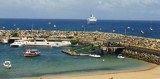

Bahia de Santo Antonio (F de Noronha N Brazil)
1.4nm
54°
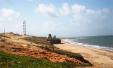
A stone pier was built for tieing up small ships. Bigger ...
12 Jan 16
Joëlle
| Latitude | Longitude | |
| DMS | --- | --- |
| DM | --- | --- |
| DD | --- | --- |


 L'archipel a été découvert en 1500 par le navigateur portugais Gaspar de Lemos, Elle est un exemple de préservation de l'environnement et possède le statut de Parc Naturel.
Il est aussi sur la liste du Patrimoine Mondial de l'Unesco.
")
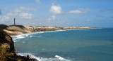
 Fernando de Noronha is an archipelago of 21 islands and islets in the Atlantic Ocean, 354 km offshore from the brazilian coast. The archipelago got its name from the Portuguese merchant Fernão de Loronha, to whom it was given by the Portuguese crown for services rendered regarding wood imported from Brazil.
Ebook | NE Brazil
|
Ebook | SW Atlantic Ocean
|