Cabo de Sao Roque (Rio Grande do Norte)

Cabo de Sao Roque (Rio Grande do Norte)

To precisely geolocate this site. Update if necessary.

Localisation

Cabo de Sao Roque (Rio Grande do Norte)
LatitudeLongitude
DMS------
DM------
DD------

Characteristics

Lighthouse

Description

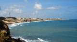
sandy point, about 55m high, with vegetation on its summit. It is closest to the continent of Africa. It also marks the separation of French Guiana (where the coast is low and swampy) and the State of Rio Grande do Norte that offers to S, a massive coast with many coves and bays.

Finally, the South Equatorial Current arrive here from the Gulf of Guinea and is divided into two branches: the Brazil Current, to S, and the North Equatorial Current, from the west, to the Caribbean (where it takes name of Gulf Stream).

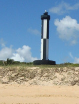
A light is shown, S of cape, built in 1898.

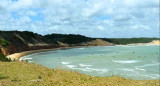
Between Cabo de Sao Roque and Punta de Santa Rita, 13 miles SSE, the coast has no remarkable features. It is backed by hills from 35 to 60m high, which are sparsely wooded, and has several villages and coconut groves along it.

2015/04/6
Update
Joëlle
Cabo de Sao Roque (Rio Grande do Norte)
2015-04-06
Update
Joëlle
Cap sablonneux d'environ 55m de haut, avec de la végétation à son sommet. C'est le plus proche du continent africain. Il marque en outre la séparation entre la Guyane française (où la côte est basse et marécageuse) et l'Etat du Rio Grande do Norte qui offre, vers le S, une côte plus massive avec beaucoup de criques et baies.

Enfin, le courant sud-équatorial arrive ici du golfe de Guinée et se divise en deux branches: le courant du Brésil, vers le S, et le courant nord-équatorial, vers l'W, jusqu'aux Caraïbes (où il prend le nom de Gulf Stream).

Le cap porte un phare au S, construit en 1898.

Entre Cabo de Sao Roque et Punta de Santa Rita, à 13 miles au SSE, la côte n'a pas rien de notable. Elle est couverte de collines de 35 à 60m de haut, qui sont peu boisées, et de plusieurs villages et plantations de cocotiers.

2015/04/6
Update
Joëlle
Ebook

NE Brazil

  • 27 sites
  • 33 photos
  • publication date: 7 Jul 2023
  • .pdf file size: 11 Mb
Share your comments or photos on "Cabo de Sao Roque (Rio Grande do Norte)"

Sites around Cabo de Sao Roque (Rio Grande do Norte)

Flying distances - Direct line

Iate Clube do Natal (Rio Grande do Norte Brazil)

17nm
168°
The Iate Clube do Natal marina is in the town of Monsenhor Gil (Brazil).

Visiting yachtsmen welcomed. Good general repair facilities. Water, showers (cold water), bar and restaurant. (Pool & recreational facilities not open to visitors). Wifi and laundry services available. ...
13 Jan 16
Joëlle

Porto do Natal (Rio Grande do Norte Brazil)

17nm
168°
The port of Natal is situated at the mouth of the Rio Pontengi. The river flows into the sea through an opening in the barrier reef. The barrier reef forms a natural breakwater for the port.
The prevailing winds most of the year are from the ENE to SE.Formalities can be carried ...
13 Jan 16
Joëlle