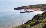
In the last century, Porto Palma (Flomentorgiu) or Tonnara Flumentorgiu was a fishing village fished and work tuna, hence its name. This activity was then abandoned because it had become unproductive.
This is a small cove, very open, to the entrance of which there are many ...
Frasca cape is the N extremity of Piana di Santadi, a plateau, which rises perpendicularly from the sea and is covered with vegetation. It is also the S extremity of the Oristano gulf. A light is shown from a structure, 8m high, standing on the cape.From this cape lies a military ...
La Caletta is a small cove that lies at the base of the cliffs of Capo San Marco.Located to the interior of Oristano Gulf, it is a natural shelter from the strong winds of the mistral. The small beach marks the transition from the dead sea to the sea alive. La Caletta is part ...
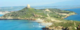
San Marco cape, limits Oristano Gulf to the N. It is a small peninsula connected to the mainland by a sandy isthmus. It has a lighthouse, 16m high tower, with two terraces on a one-story house, all yellow. S and N of the Isthmus, towers Vecchia and S. Giovanni are round and ...
The Phoenicians settled in Tharros to 800 BC, then came the turn of the Carthaginians in 500 BC. Port Tharros became a place of passage and a strong center of commercial activity. Its privileged position within the Sinis peninsula, protected from the mistral, the fertility ...


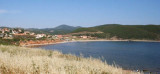


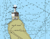
 Flumentorgiu tower, or Dei Corsari, belongs to the city of Arbus. It is conspicuous and very visible from seaward.
 La tour de Flumentorgiu, ou tour des Corsaires, appartient à la ville de Arbus. Elle est bien visible du large.
 La Torre di Flumentorgiu, o torre dei Corsari, appartiene a la comuna di Arbus. E' notevole dal largo.
")
")