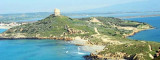

Torre di Flumentorgiu (Arbus Sardegna)
3.9nm
187°
Built in 1500, it is 60 m above sea level, visible of towers of San Giovanni of Sinis and Capo Pecora.
7 Nov 12
| Latitude | Longitude | |
| DMS | --- | --- |
| DM | --- | --- |
| DD | --- | --- |


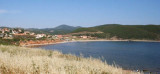
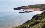
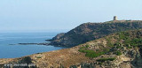
 Frasca cape is the N extremity of Piana di Santadi, a plateau, which rises perpendicularly from the sea and is covered with vegetation.
A light is shown from a structure, 8m high, standing on the cape.
From this cape lies a military polygone of Otan Capo Frasca for air exercises.
Frasca cape is una area very windy and therefore much frequented by surfers of all kinds. There are constraints for the entrance to the beach because of the military installations on the ground, so you need to learn about areas where access is allowed.
") Capo Frasca: military area.
Capo Frasca: military area. Capo Frasca est l'extrémité N du plateau Piana di Santardi, qui s'élève perpendiculairement à la mer et est recouvert de végétation.
Un phare de 8 m de haut, s'élève sur le cap.
De ce cap s'étend un polygone militaire Otan de Capo Frasca pour les exercices aériens.
Capo Frasca est souvent balayé par des vents forts et donc très fréquenté par les surfeurs de toutes sortes. Mais il y a des contraintes à l'entrée dans cette zone à cause des installations militaires sur le terrain, il faut donc s'informer sur les zones où l'accès est autorisé.
")
") Frasca cape lighthouse
Frasca cape lighthouse")
 Capo Frasca è il promontorio all'estremita N del Piano di Santadi, che si eleva perpendicolarmente verso il mare ed è coperto di vegetazione.
Un faro di 8 m di altezza, si erge sul promontorio.
Da questo capo si estende un poligono militare Otan di Capo Frasca per esercitazioni aeree.
Capo Frasca è una zona fortemente battuta dal vento e quindi molto frequentata da surfisti di ogni genere. Esistono delle limitazioni per l'ingresso al lido a causa degli insediamenti militari presenti in loco, per cui è necessario informarsi sulle zone in cui l'accesso è consentito.
Ebook | Sardegna West
|