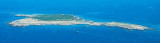
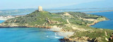
The Phoenicians settled in Tharros to 800 BC, then came the turn of the Carthaginians in 500 BC. Port Tharros became a place of passage and a strong center of commercial activity. Its privileged position within the Sinis peninsula, protected from the mistral, the fertility of the land and its mineral wealth were at the origin of its strong growth. City Tharros was finally abandoned when moving structures Oristano.
There are important archaeological remains dating from the second century BC. on the Sinis peninsula that closes the Gulf of Oristano.
You can anchor opposite the ruins by 11 m of water, 0.5 NM Tower San Giovanni dal Sinis.
2012/11/9
Update
2012-11-09
Update
Les Phéniciens s'installèrent à Tharros vers 800 av. J.-C., puis ce fut le tour des Carthaginois en 500 av. J.-C. Le port de Tharros devint un lieu de passage et un centre de forte activité commerçante. Sa position privilégiée au sein de la péninsule de Sinis, protégée du mistral, la fertilité de ses terres et sa richesse en minerais furent à l'origine de son fort développement. La ville de Tharros fut finalement abandonnée lors du déplacement des structures à Oristano.
Il subsiste d'importants vestiges archéologiques datant du IIe siècle av. J.-C. sur la péninsule de Sinis qui ferme le golfe d'Oristano.
On peut mouiller face aux ruines par 11 m d'eau, à 0,5 MN de la tour San Giovanni dal Sinis.
2012/11/9
Update
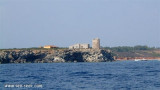
San Giovanni del Sinis tower with Tharros remains.
2012-11-09
Update
I Fenici stabilisce a Tharros a 800 BC., poi è stata la volta dei Cartaginesi nel 500 aC. Port Tharros divenne un luogo di passaggio e di un forte centro di attività commerciale. La sua posizione privilegiata all'interno della penisola del Sinis, al riparo dal maestrale, la fertilità della terra e la sua ricchezza minerale sono state all'origine della sua forte crescita. Città Tharros fu abbandonata quando si spostano Oristano strutture.
Ci sono importanti resti archeologici risalenti al II secolo aC. sulla penisola del Sinis che chiude il golfo di Oristano.
È possibile ancorare di fronte alle rovine da 11 m di acqua, 0,5 MN Torre San Giovanni dal Sinis.
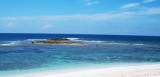
Mal di Ventre island takes its name the difficulties encountered by sailors to navigate its waters. Located opposite the Peninsula del Sunis, low and flat, 18 m high, it has an area of 80 hectares. A light is shown from a structure, 4m high, standing on the summit of the ...
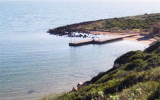
La Caletta is a small cove that lies at the base of the cliffs of Capo San Marco.Located to the interior of Oristano Gulf, it is a natural shelter from the strong winds of the mistral. The small beach marks the transition from the dead sea to the sea alive. La Caletta is part ...
San Marco cape, limits Oristano Gulf to the N. It is a small peninsula connected to the mainland by a sandy isthmus. It has a lighthouse, 16m high tower, with two terraces on a one-story house, all yellow. S and N of the Isthmus, towers Vecchia and S. Giovanni are round and ...


 AMP penisola del Sinis_I Mal di Ventre
 The Phoenicians settled in Tharros to 800 BC, then came the turn of the Carthaginians in 500 BC.
")
 Les Phéniciens s'installèrent à Tharros vers 800 av. J.-C., puis ce fut le tour des Carthaginois en 500 av. J.-C.
") San Giovanni del Sinis tower with Tharros remains.
San Giovanni del Sinis tower with Tharros remains. I Fenici stabilisce a Tharros a 800 BC., poi è stata la volta dei Cartaginesi nel 500 aC.
")
")