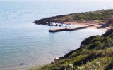
La Caletta is a small cove that lies at the base of the cliffs of Capo San Marco.Located to the interior of Oristano Gulf, it is a natural shelter from the strong winds of the mistral. The small beach marks the transition from the dead sea to the sea alive. La Caletta is part ...
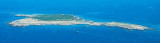
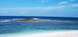
Mal di Ventre island takes its name the difficulties encountered by sailors to navigate its waters. Located opposite the Peninsula del Sunis, low and flat, 18 m high, it has an area of 80 hectares. A light is shown from a structure, 4m high, standing on the summit of the ...
The Phoenicians settled in Tharros to 800 BC, then came the turn of the Carthaginians in 500 BC. Port Tharros became a place of passage and a strong center of commercial activity. Its privileged position within the Sinis peninsula, protected from the mistral, the fertility ...


 AMP del Sinis_I Mal di Ventre
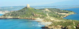
 San Marco cape, limits Oristano Gulf to the N. It is a small peninsula connected to the mainland by a sandy isthmus.
 Le cap S. Marco qui limite le golfe d'Oristano au N, est une petite presqu'île reliée à la côte par un isthme de sable.
 Capo San Marco, che limite il golfo di Oristano al N, è una picola penisola collegata alla terraferma da un istmo sabbioso.
")
")
")