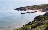
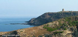
In the last century, Porto Palma (Flomentorgiu) or Tonnara Flumentorgiu was a fishing village fished and work tuna, hence its name. This activity was then abandoned because it had become unproductive.
This is a small cove, very open, to the entrance of which there are many dangers.
On the shore, we see the chimney of a canning factory.
2012/11/7
Update
Au siècle dernier, Porto Palma (Flomentorgiu) ou Tonnara di Flumentorgiu, était un village de pêcheurs qui pratiquaient la pêche et le travail du thon, d’où son nom. Cette activité fut ensuite abandonnée car elle était devenue improductive.
C'est petite anse, très ouverte, à l'entrée de laquelle se trouvent de nombreux dangers.
On voit sur la rive, la cheminée d'une usine de conserves.
2012/11/7
Update
Durante il
secolo scorso era un borgo di pescatori, che si dedicavano alla pesca
e alla lavorazione del tonno, attività a cui si deve il suo nome,
abbandonata poi per improduttività.
E' una piccola cala, molto aperta, con numerous pericoli all'imbocatura.
Si vede sulla riva, il camino di una fabbrica di conserve.
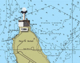
Frasca cape is the N extremity of Piana di Santadi, a plateau, which rises perpendicularly from the sea and is covered with vegetation. It is also the S extremity of the Oristano gulf. A light is shown from a structure, 8m high, standing on the cape.From this cape lies a military ...
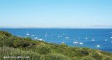
La Caletta is a small cove that lies at the base of the cliffs of Capo San Marco.Located to the interior of Oristano Gulf, it is a natural shelter from the strong winds of the mistral. The small beach marks the transition from the dead sea to the sea alive. La Caletta is part ...
San Marco cape, limits Oristano Gulf to the N. It is a small peninsula connected to the mainland by a sandy isthmus. It has a lighthouse, 16m high tower, with two terraces on a one-story house, all yellow. S and N of the Isthmus, towers Vecchia and S. Giovanni are round and ...
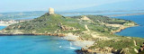
The Phoenicians settled in Tharros to 800 BC, then came the turn of the Carthaginians in 500 BC. Port Tharros became a place of passage and a strong center of commercial activity. Its privileged position within the Sinis peninsula, protected from the mistral, the fertility ...


 In the last century, Porto Palma (Flomentorgiu) or Tonnara Flumentorgiu was a fishing village fished and work tuna, hence its name. This activity was then abandoned because it had become unproductive.
 Au siècle dernier, Porto Palma (Flomentorgiu) ou Tonnara di Flumentorgiu, était un village de pêcheurs qui pratiquaient la pêche et le travail du thon, d’où son nom. Cette activité fut ensuite abandonnée car elle était devenue improductive.
 Durante il
secolo scorso era un borgo di pescatori, che si dedicavano alla pesca
e alla lavorazione del tonno, attività a cui si deve il suo nome,
abbandonata poi per improduttività.
Durante il
secolo scorso era un borgo di pescatori, che si dedicavano alla pesca
e alla lavorazione del tonno, attività a cui si deve il suo nome,
abbandonata poi per improduttività.")
")