Teluk Langsa (NE Sumatra)

Teluk Langsa (NE Sumatra)

To precisely geolocate this site. Update if necessary.

Localisation

Teluk Langsa (NE Sumatra)
LatitudeLongitude
DMS------
DM------
DD------

Characteristics

Coast

Description

Teluk Langsa (Langsa Bay) entered between Ujung Perolin and Tanjung Langsa, about 5 miles SE, is fouled by numerous shoals which are intersected by narrow channels.
The bay is easily identified by the rising ground SWof it against which the island of Pulau Telagatujoh, close NW of Telagatujoh, stands out clearly.

Telaga Tujoh (Telagatujoh), the SE entrance point of the bay, is easy to identify from the E by its sandy beach.

There are three channels of approach into Teluk Langsa, which is otherwise encumbered by numerous shoals, between which there are narrow boat channels, as follows:
1. Alur Pelayaran Birim leads from NE to the mouth of Krueng Birim. The channel is not buoyed. There are depths of 2.7 to 3m in the fairway.
2. Alur Pelayaran Telukdalam, formerly the principal channel to Pelabuhan Kualalangsa, leads close along the W side of Pulau Teleagatujoh. Apart from a fairway approach buoy, the channel is unmarked. There are least depths of 2.4m on the outer and inner bars.
3. Kuala Langsa, the principal channel, leads on the SE side of Pulau Telagatujoh through Krueng Langsa to Pelabuhan Kualalangsa.
This channel is marked by buoys and lighted range beacons.
There is a reported least depth of 1.5m close SE of range line. Vessels up to 100 dwt can reach Kualalangsa.
The tidal currents run with considerable strength in the mouths of the various rivers and generally set in the direction of the channels. The strength of the currents is sometimes felt well outside the 10m curve.

2012/01/21
Update
Jojo
Ebook

Sumatra (Indonesia)

  • 326 sites
  • 109 photos
  • publication date: 6 Jul 2023
  • .pdf file size: 100 Mb
Share your comments or photos on "Teluk Langsa (NE Sumatra)"

Sites around Teluk Langsa (NE Sumatra)

Flying distances - Direct line

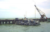
Kualalangsa harbor (NE Sumatra)

2.3nm
152°
Kuala Langsa, which is the port for the town of Langsa, stands on the left bank of the Krueng Langsa about 4 miles SW of Tanjung Langsa.
The channel depth is  0 to 1,5 m
Anchorage depth: 7,1 to 9,1 m
Cargo pier depth: 4,9 to 6,1 m
Tidal range:1,5 m
21 Jan 12
Jojo

Ujung Perolin (NE Sumatra)

3.2nm
12°
Ujung Perolin, the W entrance point of the Langsa bay, is low, sandy, covered with casuarina trees, and easily identified.
21 Jan 12
Jojo

Ujung Tamiang (NE Sumatra)

18nm
117°
The coast between Tanjung Jambuair and Ujung Tamiang, about 69 miles SE, is a low, with a few prominent features.From February through May, the higher mountains are occasionally visible. During the remainder of the year they can usually be seen, especially in the morning. Some of ...
21 Jan 12
Jojo

Ujung Peureulak (NE Sumatra)

20nm
342°
Ujung Peureulak (Tanjung Peureulak) is low and sandy point covered with high trees. Bukit Brangkat, 130m high, about 4 miles WSW of the point makes it easy to identify.
Gosong Peureula (Peureulak Bank) extends about 4 miles N and 1.5 miles E from Ujung Peureulak.
A drying patch ...
21 Jan 12
Jojo

Pangkalan Oil Terminal (NE Sumatra)

28nm
154°
Pangkalan Oil Terminal is situated 9.5 miles offshore in the outer approaches to Teluk Aru. The terminal consists of a SPM, connected to the shore by a submarine pipeline, which is marked by several special purpose buoys.
Winds—WeatherThe weather is normally fair with moderate ...
22 Jan 12
Jojo

Ujung Curam (NE Sumatra)

39nm
327°
Ujung Curam (Steile Hoek) is a point that has been reported to be radar conspicuous. A tall chimney, marked by obstruction lights, stands about 8 miles SSW of the point.
Between Tanjung Jambuair and Ujung Curam, 12 miles SE, there are several rivers and creeks.
A sandy mud bank, ...
21 Jan 12
Jojo