Ujung Perolin (NE Sumatra)
17nm
157°
21 Jan 12
Jojo
| Latitude | Longitude | |
| DMS | --- | --- |
| DM | --- | --- |
| DD | --- | --- |

 Ujung Peureulak (Tanjung Peureulak) is low and sandy point covered with high trees. Bukit Brangkat, 130m high, about 4 miles WSW of the point makes it easy to identify.
Gosong Peureula (Peureulak Bank) extends about 4 miles N and 1.5 miles E from Ujung Peureulak.
A drying patch lies close N of the point and a 0.7m patch lies 1.25 miles N of the point. The sea usually breaks over this bank.
Krueng Peureulak flows into the strait close W of Ujung Peureulak and is approached over Gosong Peureulak. In the channel at its mouth there is a depth of 0.5m and a depth of 3.5m inside the river.
The large village of Peureulak stands about 5 miles S of the entrance. Small shallow draft boats can reach the village through Kuala Leugo Rajeu about 8 miles S of Ujung Peureulak.
It is advisable to anchor as near as possible to the river mouth, steering in on a W course for Ujung Peureulak.
Kuala Beukah Oil Terminal consists of a conventional mooring buoy situated 3 miles E of Ujung Peureulak. Tankers of between 60,000 and 90,000 dwt, with a maximum length of 240m, can be accommodated in a depth of 17.5m.
Berthing is restricted to daylight hours only.
Unberthing may occur at any time. Pilot services are available.
There is a medical clinic available for vessels calling at this terminal.
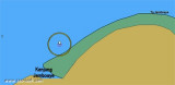
The coast between Ujung Peureulak and Ujung Tamiang, about 36 miles SE, continues low and is covered by fairly high trees. Numerous unimportant creeks intersect this stretch of coast. The coast is fringed by a mud bank, with depths of less than 5.5m, which extends from 1 to 2 miles offshore. In the vicinity of Ujung Perolin, where the bank is steep-to, about 19 miles SSE of Ujung Peureulakit extends 3.7 miles offshore.
Ebook | Sumatra (Indonesia)
|