Tavolara island is a limestone massif 6 kilometres long and 500 m wide, and 565 m high.The overhanging cliffs make it inaccessible, with the exception of a bay and a beach that is located at each end of the island, Spalmatore di Fuori northeast (military zone) and Spalmatore di Terra ...
The Caletta is located in an area where the former was portus Liguidonis Romans, it is a natural harbor.
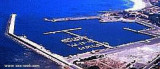
The modern harbor was built between 1956 and 1958. Formerly specialized in the trade of timber, the Caletta is now a small resort that serves the neighboring coast.
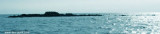
Isola Ruia (Isola Ruja) lies close inshore on the N side of the cape. It is low, rocky, reddish, and surrounded by rocks. Anchorage, sheltered from SW and NW winds, can be obtained, in a depth of 29m, sand, about 0.7 mile N of this islet. Yachts, with local knowledge, can obtain ...
Capo Comino the E extremity of Sardegna, is low, rocky, fringed by reefs. A light is shown from structure, 20m high, standing on the cape. A disused signal station is situated 0.2 mile WSW of the light.N cape Comino is Ruja (or Ruia) islet.
Islets Pedrami (Pedrami roks) lies 1 NM offshore NEof the same name point. They are surronded by several above water rocks.The passage between the rocks and the shore is only suitable for boats.
To1 NM W Pedrami tip, Mount Longu (232 m), conical, carries on its S slope ...
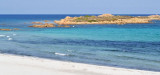
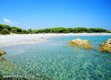
S Ginepro point is the beautiful Ginepro cove sheltered from westerly winds.Beware, for those coming from N don't pull over immediately to the beach: the S side of the point is fringed with rocks (scoglio Marchesa).We anchor in 5/6 m.


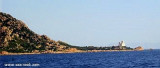
 Punta Santa Lucia, 2 NM SSE La Caletta, can be identified by a partly demolish tower.
 La pointe Santa Lucia, à 2 MN au SSE de La Caletta, se reconnait grâce à sa tour en partie démolie, qui se trouve au bord de la mer.
 Punta Santa Lucia, 2 MN SSE della Caletta, a una torre notevole, parzilamento demolita che si trova in riva al mare.
")
")