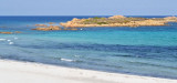
Tavolara island is a limestone massif 6 kilometres long and 500 m wide, and 565 m high.The overhanging cliffs make it inaccessible, with the exception of a bay and a beach that is located at each end of the island, Spalmatore di Fuori northeast (military zone) and Spalmatore di Terra ...
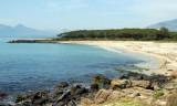
Located between the mouth of Cedrino and wild coast, there is a small cove Foche Pizzina with a small beach with a length of about 350 m, which is located between the mouth of the artificial canal that carries the waters of the river Cedrino at sea and the mouth of the river Foche ...
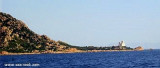
Capo Comino the E extremity of Sardegna, is low, rocky, fringed by reefs. A light is shown from structure, 20m high, standing on the cape. A disused signal station is situated 0.2 mile WSW of the light.N cape Comino is Ruja (or Ruia) islet.
Isola Ruia (Isola Ruja) lies close inshore on the N side of the cape. It is low, rocky, reddish, and surrounded by rocks. Anchorage, sheltered from SW and NW winds, can be obtained, in a depth of 29m, sand, about 0.7 mile N of this islet. Yachts, with local knowledge, can obtain ...


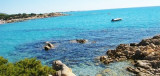
 S Ginepro point is the beautiful Ginepro cove sheltered from westerly winds.
 Au S de la pointe Ginepro se trouve la belle anse Ginepro protégée des vents d'W.
 S punta Ginepro si trova la bella cala Ginepro ridossata dai venti occidentali.
")
")
")
")