Tavolara island is a limestone massif 6 kilometres long and 500 m wide, and 565 m high.The overhanging cliffs make it inaccessible, with the exception of a bay and a beach that is located at each end of the island, Spalmatore di Fuori northeast (military zone) and Spalmatore di Terra ...
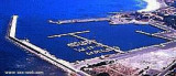
The Caletta is located in an area where the former was portus Liguidonis Romans, it is a natural harbor.
The modern harbor was built between 1956 and 1958. Formerly specialized in the trade of timber, the Caletta is now a small resort that serves the neighboring coast.
Isolotto d'Ottiolu, low and inconspicuous, lies 1 mile S of Ottiolu cape and is marked by a light. A submerged reef extends about 0.5 mile E of this islet.
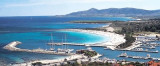
Porto Ottiolu marina is located just SW of Punta di Ottiolu. T. 846211/846213Fax: 846209 Mail: info@marinaportoottiolu.com 405 b. incl. 40 visit. (<18,5 m)
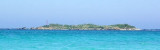
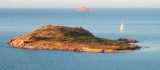
Isola Molara, private island, S Tavolara island, 158m high, is undulating and partially cultivated.The coasts are high and rocky at E (Punta Levante et Punta di Sirocco), they are more practicable with the few beaches and coves located in NW (Cala Cala Chiesa e Spagnola).We see a ...


 Islets Pedrami (Pedrami roks) lies 1 NM offshore NEof the same name point. They are surronded by several above water rocks.
 Les rochers Pedrami émergent à 1M au NE au large de la pointe du même nom. Ils sont entourés de nombreux rochers submergés.
 Isolotti Pedrami (scoglie Pedrami) emergono 1MN NE al largo della punta con lo stesso nome. Sono circondati da numerosi scogli sommersi.
")
")