The Caletta is located in an area where the former was portus Liguidonis Romans, it is a natural harbor.
The modern harbor was built between 1956 and 1958. Formerly specialized in the trade of timber, the Caletta is now a small resort that serves the neighboring coast.
The harbor is protected from winds SE, SW and NW.
Boaters are mostly welcomed on the N side of the basin.
T. +39.0784.810137
450 berths (<20 m)
Danger: Pedrami rocks beyond the coast near 1.25 m eastward. It is prudent to remain well offshore.
2012/10/5
Update
Joëlle
2012-10-05
Update
Joëlle
La Caletta se trouve dans une zone où était l'ancien portus Liguidonis des Romains, c'est un port naturel.
Le petit port moderne fut réalisé entre 1956 et 1958. Autrefois spécialisé dans le commerce des bois de construction, la Caletta est maintenant une petite station touristique qui dessert la côte voisine.
Le port est protégé des vents de SE, SW et NW.
Les plaisanciers sont, pour la plupart, accueillis sur le côté N du bassin.
T. +39.0784.810137
450 places (<20 m)
Danger: les rochers de Pedrami débordent la côte sur près de 1,25m vers l'E. Il est prudent de rester bien au large.
2012/10/5
Update
Joëlle
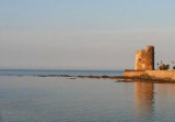
La tour de La Caletta
2012-10-05
Update
Joëlle
Partie "privée" sur tribord, voir au club nautique; partie publique sur babord, pontons et catways en mauvais état, pas d'eau pas d'électricité mais gratuits (05.2009) gazole et eau possibles côté pêcheurs,avitaillement en ville.
2012/10/5
Update
Joëlle
2012-10-05
Update
Joëlle
La Caletta si trova sulla costa Orientale Sarda a 50 Km. a su di Olbia , dotata di un Porto turistico di circa 500 posti barca e base di una delle più grandi flotte pescherecce della Sardegna.
Il porticciolo è stato realizzato tra il 1956 e il 1958 come porto commerciale , trasformandosi pian piano in approdo turistico . La Caletta è oggi una località turistica importante sia nel periodo estivo quanto in quello invernale , con i suoi 2500 residenti offre tutti i servizi : Market ( Sea Shop ) , banca , farmacia , hotel , ristoranti ,(Trattoria Mamma Mia ), Gite in barca ( Pastori di Mare ), Etc.
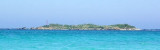
Tavolara island is a limestone massif 6 kilometres long and 500 m wide, and 565 m high.The overhanging cliffs make it inaccessible, with the exception of a bay and a beach that is located at each end of the island, Spalmatore di Fuori northeast (military zone) and Spalmatore di Terra ...
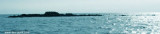
Islets Pedrami (Pedrami roks) lies 1 NM offshore NEof the same name point. They are surronded by several above water rocks.The passage between the rocks and the shore is only suitable for boats.
To1 NM W Pedrami tip, Mount Longu (232 m), conical, carries on its S slope ...
Isola Ruia (Isola Ruja) lies close inshore on the N side of the cape. It is low, rocky, reddish, and surrounded by rocks. Anchorage, sheltered from SW and NW winds, can be obtained, in a depth of 29m, sand, about 0.7 mile N of this islet. Yachts, with local knowledge, can obtain ...
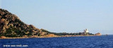
Capo Comino the E extremity of Sardegna, is low, rocky, fringed by reefs. A light is shown from structure, 20m high, standing on the cape. A disused signal station is situated 0.2 mile WSW of the light.N cape Comino is Ruja (or Ruia) islet.
Isolotto d'Ottiolu, low and inconspicuous, lies 1 mile S of Ottiolu cape and is marked by a light. A submerged reef extends about 0.5 mile E of this islet.


 canal 9, 16


 B G M
B G M  B G M
B G M 

 Libero


 Market Sea Shop
 Trattoria Mamma Mia


 The Caletta is located in an area where the former was portus Liguidonis Romans, it is a natural harbor.
")
 La Caletta se trouve dans une zone où était l'ancien portus Liguidonis des Romains, c'est un port naturel.
") La tour de La Caletta
La tour de La Caletta")
 La Caletta si trova sulla costa Orientale Sarda a 50 Km. a su di Olbia , dotata di un Porto turistico di circa 500 posti barca e base di una delle più grandi flotte pescherecce della Sardegna.