Golfo degli Aranci (Sardegna)
6nm
320°
28 Sep 12
Joëlle
| Latitude | Longitude | |
| DMS | --- | --- |
| DM | --- | --- |
| DD | --- | --- |


")
")
")
Ebook | Sardegna East
|
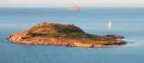
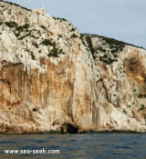
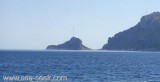
 Tavolara island is a limestone massif 6 kilometres long and 500 m wide, and 565 m high.
The overhanging cliffs make it inaccessible, with the exception of a bay and a beach that is located at each end of the island, Spalmatore di Fuori northeast (military zone) and Spalmatore di Terra southwest .
Currently, the island is inhabited by only a handful of families, and a small cemetery and summer restaurant.
The seabed is of considerable interest to scientists and naturalists.
Islands and Molara Molarotto are nearby.
It is located in the natural area protected Tavolara - Punta Cavallo.
The navigation in the NE of the island is off-limits for the presence of a military zone and it is prohibited to anchor.
 L'île de Tavolara est une plateforme granitique à l'aspect d'une montagne rocheuse qui émerge de la mer. Longue de 6 kms, large de 500 m et haute de 565 m.
Les falaises en surplomb la rendent inaccessible, à l'exception d'une baie et une plage qui se trouvent à chaque extrémité de l'île, Spalmatore di Fuori au nord-est (zone militaire), et Spalmatore di Terra au sud-ouest.
Actuellement, l'île est habitée par seulement une poignée de familles, et a un petit cimetière et restaurant d'été.
Les fonds marins sont d'un intérêt considérable pour les scientifiques et naturalistes.
Les îles de Molara et Molarotto sont à proximité.
Elle se trouve dans l'Area naturale protetta Tavolara - Punta Cavallo.
La navigation dans la partie NE de l'île est interdite à cause de la présence d'une zone militaire et l'ancrage est interdit.
 L'isola di Tavorala si presenta come un maestoso massiccio calcareo a picco sul mare. Lunga di 6 km, largo 500 m e alta 565 m.
Le scogliere a strapiombo la rendono inaccessibile, con l'eccezione di una baia e una spiaggia che si trovano a ciascuna estremità dell'isola, Spalmatore di Fuori nord-est (zona militare) e Terra di Spalmatore a sud ovest .
Attualmente, l'isola è abitata solo da una manciata di famiglie, e un piccolo cimitero e ristorante estivo.
Il fondale è di notevole interesse per gli scienziati e naturalisti.
Isole e Molara Molarotto si trovano nelle vicinanze.
Si trova nell'Area naturale protetta Tavolara - Punta Cavallo.
La navigazione nella parte nord - est dell’isola è interdetta per la presenza di una zona militare ed è vietato l’ancoraggio.
Ebook | Sardegna
|
")
")