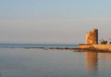
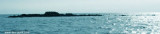
Isola Ruia (Isola Ruja) lies close inshore on the N side of the cape. It is low, rocky, reddish, and surrounded by rocks.
Anchorage, sheltered from SW and NW winds, can be obtained, in a depth of 29m, sand, about 0.7 mile N of this islet. Yachts, with local knowledge, can obtain shelter from SE winds, closer inshore, in depths of 10m.
2012/10/8
Update
Joëlle
Isola Ruia (isola Ruja) se trouve à proximité des côtes sur le côté N
du cap. Elle est basse, rocheuse, rougeâtre, et entourée de rochers.
On peut mouiller, à l'abri des vents de NW et SW, par 29 m, à environ 0,7 MN au N de l'îlot. Les plaisanciers avec une connaissance locale, peuvent trouver un abri contre les vents de SE, près des côtes, par 10 m de fond.
2012/10/8
Update
Joëlle
Isola Ruia(Ruja) si trova vicino alla costa sul lato N di capo Comino. E 'bassa, rocciosa, rossastra, e circondata da rocce.
È possibile ancorare, al riparo dei venti NW e SW da 29 m, circa 0,7 MN N dell'isola. Si puo ancorare con la conoscenza locale, e si puo trovare riparo contro il vento SE, vicino alla costa, da 10 m di profondità.
Tavolara island is a limestone massif 6 kilometres long and 500 m wide, and 565 m high.The overhanging cliffs make it inaccessible, with the exception of a bay and a beach that is located at each end of the island, Spalmatore di Fuori northeast (military zone) and Spalmatore di Terra ...
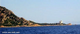
Capo Comino the E extremity of Sardegna, is low, rocky, fringed by reefs. A light is shown from structure, 20m high, standing on the cape. A disused signal station is situated 0.2 mile WSW of the light.N cape Comino is Ruja (or Ruia) islet.
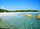
S Ginepro point is the beautiful Ginepro cove sheltered from westerly winds.Beware, for those coming from N don't pull over immediately to the beach: the S side of the point is fringed with rocks (scoglio Marchesa).We anchor in 5/6 m.
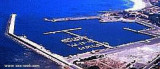
The Caletta is located in an area where the former was portus Liguidonis Romans, it is a natural harbor.
The modern harbor was built between 1956 and 1958. Formerly specialized in the trade of timber, the Caletta is now a small resort that serves the neighboring coast.
Islets Pedrami (Pedrami roks) lies 1 NM offshore NEof the same name point. They are surronded by several above water rocks.The passage between the rocks and the shore is only suitable for boats.
To1 NM W Pedrami tip, Mount Longu (232 m), conical, carries on its S slope ...


 Isola Ruia (Isola Ruja) lies close inshore on the N side of the cape. It is low, rocky, reddish, and surrounded by rocks.
 Isola Ruia (isola Ruja) se trouve à proximité des côtes sur le côté N
du cap. Elle est basse, rocheuse, rougeâtre, et entourée de rochers.
Isola Ruia (isola Ruja) se trouve à proximité des côtes sur le côté N
du cap. Elle est basse, rocheuse, rougeâtre, et entourée de rochers. Isola Ruia(Ruja) si trova vicino alla costa sul lato N di capo Comino. E 'bassa, rocciosa, rossastra, e circondata da rocce.
")
")
")