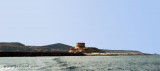
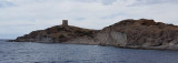
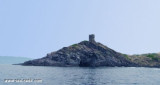
The commercial harbor consists of a pier attached to Rossa island. The island is connected to the mainland by a causeway. It is accessible in good weather, by boats with 2.5 m draugh. It is more an anchorage than a port.
T. 0785-375468
120 b. (<50 m)
Depth: de 1,5 à 7 m.
2012/11/14
Update
Joëlle
Le port commercial est constitué d'une jetée accrochée à l'île Rossa. L'île est reliée à la terre ferme par une digue. Il est accessible, par beau temps, aux bateaux de 2,5 m de TE. C'est plus un mouillage qu'un port.
T. 0785-375468
120 pl. (<50 m)
Profondeur: de 1,5 à 7 m.
2012/11/14
Update
Joëlle
Il Porto Commerciale è costituita da un molo collegata all'E d'isola Rossa. L'isola è collegata alla terraferma da una diga. E' accessibile con il bel tempo, alle barche di 2,5 m di pescaggio. E' più un'ancoraggio che uno porto.
The park begins at Capo Galera to continue toward the gulf of Porto Conte that is protected by two promontories, Punta Giglio and Capo Caccia-Monte Timidone. The marine protected area embraces the stretch of sea to the north-west of Punta Cristallo.Almost all of the park consists ...
Rossa island , 15 m high, lies just before the S entrance point of Temo river. A large and conspicuous tower stands on the summit of the island.It is connected to the mainland by a breakwater.S island, a small rocky breakwater extends SSE from S extremity and protects Bosa bay ...
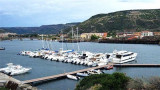
The river port is located on the Temo river and is only accessible by calm sea. An area reserved for the craft is at the Base Nautica Pinna and the new docking station (nuova darsena).
Attention, by strong wind the input and output port are very dangerous.
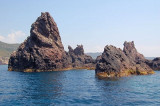
At about 1 NM from the coast, along Tresnuraghes marina, near Bosa, there is a sea strewn with rocks and islets. It is the "Corona Niedda" an archipelago of volcanic origin who won with its largest island, about 40 m high.


 canal 16, 14


 The commercial harbor consists of a pier attached to Rossa island. The island is connected to the mainland by a causeway.
 Le port commercial est constitué d'une jetée accrochée à l'île Rossa. L'île est reliée à la terre ferme par une digue.
 Il Porto Commerciale è costituita da un molo collegata all'E d'isola Rossa. L'isola è collegata alla terraferma da una diga.