The park begins at Capo Galera to continue toward the gulf of Porto Conte that is protected by two promontories, Punta Giglio and Capo Caccia-Monte Timidone. The marine protected area embraces the stretch of sea to the north-west of Punta Cristallo.Almost all of the park consists ...
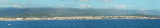
Rada di Alghero is entered between S, the town of Alghero and N, capo Galera.The E shore of this bay is low and sandy, and the W shore is hilly and rocky. An undulating coastal plain, partly under cultivation, lies immediately inland of the head of this bay.This bay is open to ...
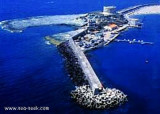
Rossa island , 15 m high, lies just before the S entrance point of Temo river. A large and conspicuous tower stands on the summit of the island.It is connected to the mainland by a breakwater.S island, a small rocky breakwater extends SSE from S extremity and protects Bosa bay ...
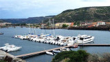
The river port is located on the Temo river and is only accessible by calm sea. An area reserved for the craft is at the Base Nautica Pinna and the new docking station (nuova darsena).
Attention, by strong wind the input and output port are very dangerous.
The commercial harbor consists of a pier attached to Rossa island. The island is connected to the mainland by a causeway. It is accessible in good weather, by boats with 2.5 m draugh. It is more an anchorage than a port. T. 0785-375468 120 b. (<50 m)Depth: de 1,5 à 7 m.


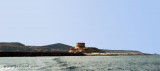
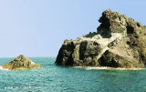
 Argentina spanish tower(1578) is on a limestone promontory, 33 m above sea level, 2.5 NM N of Isola Rossa.
 La tour espagnole Argentina (1578) se trouve sur un promontoire calcaire, à 33 m au-dessus du niveau de la mer, à 2,5 MN au N d'Isola Rossa.
 La torre spagnola Argentina (1578) si trova su uno promontorio calcareo, a 33 m sul mare, a 2,5 MN al N dell'isola Rossa.
")
") Argentina tower see from N.
Argentina tower see from N.") Mooring possible in the South East of the tower
Mooring possible in the South East of the tower") Mooring by 13m depth.
Mooring by 13m depth.")