Isola Rossa (Bosa Sardegna)

Isola Rossa (Bosa Sardegna)

To precisely geolocate this site. Update if necessary.

Localisation

Isola Rossa (Bosa Sardegna)
LatitudeLongitude
DMS------
DM------
DD------

Characteristics

Island / Atoll

Description

Rossa island , 15 m high, lies just before the S entrance point of Temo river.
A large and conspicuous tower stands on the summit of the island.

It is connected to the mainland by a breakwater.

S island, a small rocky breakwater extends SSE from S extremity and protects Bosa bay from wind.

A quay lies E of the island and makes the commercial port.

2012/11/14
Update
Joëlle
L'île Rossa, 15 m de haut, est située juste avant l'estuaire du fleuve Temo.
Une grande tour remarquable s'élève sur le sommet de l'île.

Elle est reliée à la terre par une digue.

Au S de l'île, au SSE de son extrémité, s'étend une petite jetée en rocher qui protège l'anse de Bosa du vent. 

Un quai s'étend à E de l'île et forme le port commercial de Bosa.


2012/11/14
Update
Joëlle
Isola Rossa, 15 m alta, è situata poco prima dalla foce del fiume Temo.
Una grande torre notevole sorge sulla sommità dell'isola.

E 'collegata alla terraferma da una diga.

All'S dell'isola, fine SSE si trova un piccolo molo roccioso che protegge la baia Bosa dal vento.

Un pontile si estende E dell'isola e forma il porto commerciale di Bosa.

2012/11/14
Update
Joëlle
Isola Rossa (Bosa Sardegna)
2012-11-14
Update
Joëlle
Isola Rossa (Bosa Sardegna)
Isola Rossa tower
2012-11-14
Update
Joëlle
Isola Rossa (Bosa Sardegna)
2012-11-14
Update
Joëlle
Ebook

Sardegna West

  • 122 sites
  • 310 photos
  • publication date: 11 Jul 2023
  • .pdf file size: 59 Mb
Ebook

Sardegna

  • 444 sites
  • 1069 photos
  • publication date: 11 Jul 2023
  • .pdf file size: 243 Mb
Share your comments or photos on "Isola Rossa (Bosa Sardegna)"

Sites around Isola Rossa (Bosa Sardegna)

Flying distances - Direct line

Area Marina Protetta di Capo Caccia - I. Piana (Sardegna)

22nm
325°
The park begins at Capo Galera to continue toward the gulf of Porto Conte that is protected by two promontories, Punta Giglio and Capo Caccia-Monte Timidone. The marine protected area embraces the stretch of sea to the north-west of Punta Cristallo.Almost all of the park consists ...
20 Nov 12
Joëlle

Porto commerciale Bosa Marina

0nm
71°
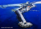
The commercial harbor consists of a pier attached to Rossa island. The island is connected to the mainland by a causeway.
It is accessible in good weather, by boats with 2.5 m draugh.
It is more an anchorage than a port.
T. 0785-375468 120 b. (<50 m)Depth: de 1,5 à 7 m.
14 Nov 12
Joëlle

Porto fluviale Bosa Marina (Sardegna)

0.5nm
34°
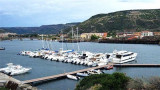
The river port is located on the Temo river and is only accessible by calm sea.
An area reserved for the craft is at the Base Nautica Pinna and the new docking station (nuova darsena).

Attention, by strong wind the input and output port are very dangerous.

Only boat ...
14 Nov 12
Joëlle

Torre Argentina (Bosa Sardegna)

2.2nm
328°
Argentina  spanish tower(1578) is on a limestone promontory, 33 m above sea level, 2.5 NM N of Isola Rossa.
14 Nov 12
Joëlle

Scogli di Corona Niedda (Sardegna)

4.7nm
189°
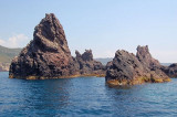
At about 1 NM from the coast, along Tresnuraghes marina, near Bosa, there is a sea strewn with rocks and islets. It is the "Corona Niedda" an archipelago of volcanic origin who won with its largest island, about 40 m high.
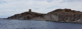
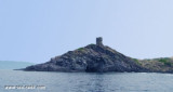
It is a diving spot.
14 Nov 12
Joëlle