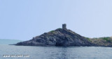
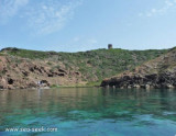
At about 1 NM from the coast, along Tresnuraghes marina, near Bosa, there is a sea strewn with rocks and islets. It is the "Corona Niedda" an archipelago of volcanic origin who won with its largest island, about 40 m high.
It is a diving spot.
2012/11/14
Update
Joëlle
A environ 1 MN de la côte, le long de la marina de Tresnuraghes, près de Bosa, on trouve une mer parsemée de rochers et d'îlots. C'est "Corona Niedda", un archipel d'origine volcanique qui s'impose avec sa plus grande île, à environ 40 m de haut.
C'est un spot de plongée.
2012/11/14
Update
Joëlle
A circa un miglio dalla costa, lungo la
marina di Tresnuraghes, vicino a Bosa, si incontra un mare costellata da scogli e isolotti. È "Corona Niedda", l’arcipelago di
origine vulcanica che si impone con la sua isola maggiore, alta una
quarantina di metri.
The park begins at Capo Galera to continue toward the gulf of Porto Conte that is protected by two promontories, Punta Giglio and Capo Caccia-Monte Timidone. The marine protected area embraces the stretch of sea to the north-west of Punta Cristallo.Almost all of the park consists ...
Foghe cape is a small volcanic rock promontory that is N Nieddu cape and S Bosa, bordered to S by Mannu river.Foghe tower stands on the NW side of the point and is remarkable. The Cuglieri city and cathedral are 4.5 NM E of the tower and are clearly visible from the sea
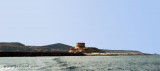
The capo Nieddu spanish tower is 1 km on a tip after the beautiful and single cascade throughout the region formed by the river Mannu, which flows into the sea from its 40 m high.
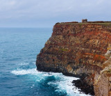
Situated on the cliff at 68 m above sea level, the Nieddu tower is in visual contact with the ...
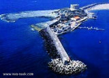
Rossa island , 15 m high, lies just before the S entrance point of Temo river. A large and conspicuous tower stands on the summit of the island.It is connected to the mainland by a breakwater.S island, a small rocky breakwater extends SSE from S extremity and protects Bosa bay ...
The commercial harbor consists of a pier attached to Rossa island. The island is connected to the mainland by a causeway. It is accessible in good weather, by boats with 2.5 m draugh. It is more an anchorage than a port. T. 0785-375468 120 b. (<50 m)Depth: de 1,5 à 7 m.


 At about 1 NM from the coast, along Tresnuraghes marina, near Bosa, there is a sea strewn with rocks and islets. It is the "Corona Niedda" an archipelago of volcanic origin who won with its largest island, about 40 m high.
 A environ 1 MN de la côte, le long de la marina de Tresnuraghes, près de Bosa, on trouve une mer parsemée de rochers et d'îlots. C'est "Corona Niedda", un archipel d'origine volcanique qui s'impose avec sa plus grande île, à environ 40 m de haut.
 A circa un miglio dalla costa, lungo la
marina di Tresnuraghes, vicino a Bosa, si incontra un mare costellata da scogli e isolotti. È "Corona Niedda", l’arcipelago di
origine vulcanica che si impone con la sua isola maggiore, alta una
quarantina di metri.
A circa un miglio dalla costa, lungo la
marina di Tresnuraghes, vicino a Bosa, si incontra un mare costellata da scogli e isolotti. È "Corona Niedda", l’arcipelago di
origine vulcanica che si impone con la sua isola maggiore, alta una
quarantina di metri.")
")