The park begins at Capo Galera to continue toward the gulf of Porto Conte that is protected by two promontories, Punta Giglio and Capo Caccia-Monte Timidone. The marine protected area embraces the stretch of sea to the north-west of Punta Cristallo.Almost all of the park consists ...
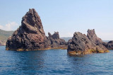
At about 1 NM from the coast, along Tresnuraghes marina, near Bosa, there is a sea strewn with rocks and islets. It is the "Corona Niedda" an archipelago of volcanic origin who won with its largest island, about 40 m high.
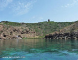
Foghe cape is a small volcanic rock promontory that is N Nieddu cape and S Bosa, bordered to S by Mannu river.Foghe tower stands on the NW side of the point and is remarkable. The Cuglieri city and cathedral are 4.5 NM E of the tower and are clearly visible from the sea
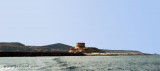
Rossa island , 15 m high, lies just before the S entrance point of Temo river. A large and conspicuous tower stands on the summit of the island.It is connected to the mainland by a breakwater.S island, a small rocky breakwater extends SSE from S extremity and protects Bosa bay ...
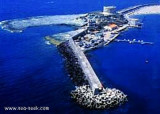
The commercial harbor consists of a pier attached to Rossa island. The island is connected to the mainland by a causeway. It is accessible in good weather, by boats with 2.5 m draugh. It is more an anchorage than a port. T. 0785-375468 120 b. (<50 m)Depth: de 1,5 à 7 m.
The capo Nieddu spanish tower is 1 km on a tip after the beautiful and single cascade throughout the region formed by the river Mannu, which flows into the sea from its 40 m high.
Situated on the cliff at 68 m above sea level, the Nieddu tower is in visual contact with the ...


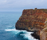
 Torre Columbargia, 33m high, stands on a reddish hill, 1.2 NM of Torre Foghe.
  Torre Columbargia, haute de 33 m, s'élève à la pointe d'une montagne rouge, à 1,2 MN de la pointe Foghe.
  Torre Columbargia, 33 m alta, è alla punta di uno mantagna rossa, a 1,2 MN dalla punta Foghe.
")
")
")