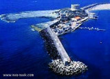
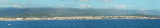
The river port is located on the Temo river and is only accessible by calm sea. An area reserved for the craft is at the Base Nautica Pinna and the new docking station (nuova darsena).
Attention, by strong wind the input and output port are very dangerous.
Only boat with a maximum of 2 m draugh can enter the port.
Le port fluvial se trouve sur le fleuve Temo et n'est accessible que par mer calme. Une aire réservée à la plaisance se trouve à la Base Nautica Pinna et à la nouvelle station d'accueil (nuova darsena).
Attention par fort vent l'entrée et la sortie du port sont très dangereuses.
Seuls les bateau avec un TE maximum de 2 m peuvent pénétrer dans le port.
L'entrée est indiquée par des piliers de 1 m de haut.
Il porto fluviale si trova sullo fiumo Temo e è accessibile solo da mare calma. Una area riservata al diporto si trova alla Basa Nautica Pina e alla nuova darsena.
Attenzione, con vento e mare da W e/o NW e con forte risacca, l'ingresso e/o l'uscita dal porto fluviale risulta molto pericolosa.
Possono accedere nel porto canale solo unità con un pescaggio massimo di 2 m.
The park begins at Capo Galera to continue toward the gulf of Porto Conte that is protected by two promontories, Punta Giglio and Capo Caccia-Monte Timidone. The marine protected area embraces the stretch of sea to the north-west of Punta Cristallo.Almost all of the park consists ...
The commercial harbor consists of a pier attached to Rossa island. The island is connected to the mainland by a causeway. It is accessible in good weather, by boats with 2.5 m draugh. It is more an anchorage than a port. T. 0785-375468 120 b. (<50 m)Depth: de 1,5 à 7 m.
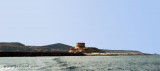
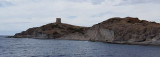
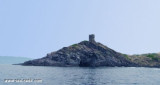
Rossa island , 15 m high, lies just before the S entrance point of Temo river. A large and conspicuous tower stands on the summit of the island.It is connected to the mainland by a breakwater.S island, a small rocky breakwater extends SSE from S extremity and protects Bosa bay ...
Rada di Alghero is entered between S, the town of Alghero and N, capo Galera.The E shore of this bay is low and sandy, and the W shore is hilly and rocky. An undulating coastal plain, partly under cultivation, lies immediately inland of the head of this bay.This bay is open to ...


 canal 09, 73


 The river port is located on the Temo river and is only accessible by calm sea.
")
 Le port fluvial se trouve sur le fleuve Temo et n'est accessible que par mer calme.
")
 Il porto fluviale si trova sullo fiumo Temo e è accessibile solo da mare calma.
")