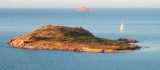
A 15 NM E Molara Island, Molarotto island (51 m) is conical and reddish because it consists of granite. This is the ultimate outpost of land before the open sea.
Cervi rocks, or Three Brothers'rocks, extend between Molara and Molarotto.
The passage between these rocks and Molarotto is not recommended.
2012/10/3
Update
Joëlle
A 15 M à l'E de l'île Molara, l'îlot Molarotto (51 m) est conique et de couleur rougeâtre car constituée de granite. C'est l'ultime avant poste de terre avant la pleine mer.
Les rochers Cervi, ou rochers des Trois Frères, s'étendent entre Molara et Molarotto.
Le passage entre ces rochers et Molarotto est déconseillé.
2012/10/3
Update
Joëlle
A 15 MN E isola Molara, l'isola di Molarotto (51 m) è conica e rossastra perché è costituito da granito. Questo è l'ultimo avamposto di terra prima del mare aperto.
Le rocce Cervi, o rocce dei tre fratelli, e si estendono tra Molara e Molarotto.
Il passaggio tra queste rocce e Molarotto non è raccomandato.
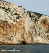
Tavolara island is a limestone massif 6 kilometres long and 500 m wide, and 565 m high.The overhanging cliffs make it inaccessible, with the exception of a bay and a beach that is located at each end of the island, Spalmatore di Fuori northeast (military zone) and Spalmatore di Terra ...
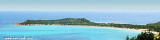
Isola Molara, private island, S Tavolara island, 158m high, is undulating and partially cultivated.The coasts are high and rocky at E (Punta Levante et Punta di Sirocco), they are more practicable with the few beaches and coves located in NW (Cala Cala Chiesa e Spagnola).We see a ...
Degli Aranci gulf is is bounded, on the N, by the peninsula of which Capo Figari is the E extremity.This gulf is sheltered from NE and NW winds. Strong SE winds send in a heavy sea and storms from the N and E cause a considerable swell in the gulf. During offshore winds, which are ...
This long peninsula beyond the promontory of Monte Petruso, extending into the Tyrrhenian Sea, has an end portion which is called "Capo Coda Cavallo" ("Queue of horse cape"), because of its curious shape.
This is the extreme point of the marine protected area of Tavolara / ...
Tavolara Island had a strategic importance in 1861. Merchant Navy built
with the cooperation of the prisoners on the island at the time, at
Spalmatore di Fuori, a lighthouse of 2 floors.
The lighthouse was
built on the mountain falls steeply to the sea and it was therefore ...


 A 15 NM E Molara Island, Molarotto island (51 m) is conical and reddish because it consists of granite. This is the ultimate outpost of land before the open sea.
 A 15 M à l'E de l'île Molara, l'îlot Molarotto (51 m) est conique et de couleur rougeâtre car constituée de granite. C'est l'ultime avant poste de terre avant la pleine mer.
 A 15 MN E isola Molara, l'isola di Molarotto (51 m) è conica e rossastra perché è costituito da granito. Questo è l'ultimo avamposto di terra prima del mare aperto.
")