Tavolara Island had a strategic importance in 1861. Merchant Navy built
with the cooperation of the prisoners on the island at the time, at
Spalmatore di Fuori, a lighthouse of 2 floors.
The lighthouse was
built on the mountain falls steeply to the sea and it was therefore
necessary to develop a narrow winding road to reach it, which partially
altered the natural landscape of the island.
The lighthouse was active until 1920, when it was replaced by the advanced Timone.
2012/10/3
Update
Joëlle
Le vieux phare de Punta Papa.
2012-10-03
Update
Joëlle
L'île de Tavolara a eu une grande importance stratégique en 1861. La
Marine Marchande construisit, avec la coopération des détenus présents
sur l'île à l'époque, à Spalmatore di Fuori, un phare de 2 étages.
Le
phare fut construit sur la montagne qui tombe à pic sur la mer et il
fut alors nécessaire d'aménager une route tortueuse et étroite pour
pouvoir l'atteindre, ce qui modifiait partiellement le paysage naturel
de l'île.
Le phare fut actif jusqu'en 1920, date à laquelle il fut remplacé par celui de pointe Timone.
2012/10/3
Update
Joëlle
Il vecchio faro di Punta Papa
2012-10-03
Update
Joëlle
Isola di Tavolara aveva una importanza strategica nel 1861. Marina
Mercantile a costruito con la collaborazione dei prigionieri sull'isola
al momento, a Spalmatore di Fuori, un faro di 2 piani.
Il faro
è stato costruito sul monte scende ripidamente verso il mare ed è stato
quindi necessario sviluppare una strada stretta e tortuosa per
raggiungerla, che ha parzialmente modificato il paesaggio naturale
dell'isola.
Il faro è stato attivo fino al 1920, quando fu sostituito quello dal Timone.
2012/10/3
Update
Joëlle
the narrow winding road to reach the old lighthouse
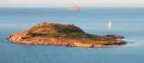
Tavolara island is a limestone massif 6 kilometres long and 500 m wide, and 565 m high.The overhanging cliffs make it inaccessible, with the exception of a bay and a beach that is located at each end of the island, Spalmatore di Fuori northeast (military zone) and Spalmatore di Terra ...
Degli Aranci gulf is is bounded, on the N, by the peninsula of which Capo Figari is the E extremity.This gulf is sheltered from NE and NW winds. Strong SE winds send in a heavy sea and storms from the N and E cause a considerable swell in the gulf. During offshore winds, which are ...
Isola Molara, private island, S Tavolara island, 158m high, is undulating and partially cultivated.The coasts are high and rocky at E (Punta Levante et Punta di Sirocco), they are more practicable with the few beaches and coves located in NW (Cala Cala Chiesa e Spagnola).We see a ...
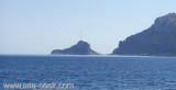
Cala del Faro, a cove where are facilities of the NATO radar base, lies on the S of Punta Timone. Here there is a ban on navigation is less than 500 meters from the coast, for reasons of military security.
The lighthouse of Punta Timone at the NE end of the island, is a white octagonal tower 7 m high. Its range is 15 NM. It is also equipped with a lantern reserve with a minimum range of 12 NM.


 Tavolara Island had a strategic importance in 1861. Merchant Navy built
with the cooperation of the prisoners on the island at the time, at
Spalmatore di Fuori, a lighthouse of 2 floors.
Tavolara Island had a strategic importance in 1861. Merchant Navy built
with the cooperation of the prisoners on the island at the time, at
Spalmatore di Fuori, a lighthouse of 2 floors.") Le vieux phare de Punta Papa.
Le vieux phare de Punta Papa. L'île de Tavolara a eu une grande importance stratégique en 1861. La
Marine Marchande construisit, avec la coopération des détenus présents
sur l'île à l'époque, à Spalmatore di Fuori, un phare de 2 étages.
L'île de Tavolara a eu une grande importance stratégique en 1861. La
Marine Marchande construisit, avec la coopération des détenus présents
sur l'île à l'époque, à Spalmatore di Fuori, un phare de 2 étages.") Il vecchio faro di Punta Papa
Il vecchio faro di Punta Papa Isola di Tavolara aveva una importanza strategica nel 1861. Marina
Mercantile a costruito con la collaborazione dei prigionieri sull'isola
al momento, a Spalmatore di Fuori, un faro di 2 piani.
Isola di Tavolara aveva una importanza strategica nel 1861. Marina
Mercantile a costruito con la collaborazione dei prigionieri sull'isola
al momento, a Spalmatore di Fuori, un faro di 2 piani.") the narrow winding road to reach the old lighthouse
the narrow winding road to reach the old lighthouse