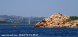
Tavolara island is a limestone massif 6 kilometres long and 500 m wide, and 565 m high.The overhanging cliffs make it inaccessible, with the exception of a bay and a beach that is located at each end of the island, Spalmatore di Fuori northeast (military zone) and Spalmatore di Terra ...
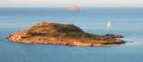
Isola Molara, private island, S Tavolara island, 158m high, is undulating and partially cultivated.The coasts are high and rocky at E (Punta Levante et Punta di Sirocco), they are more practicable with the few beaches and coves located in NW (Cala Cala Chiesa e Spagnola).We see a ...
Degli Aranci gulf is is bounded, on the N, by the peninsula of which Capo Figari is the E extremity.This gulf is sheltered from NE and NW winds. Strong SE winds send in a heavy sea and storms from the N and E cause a considerable swell in the gulf. During offshore winds, which are ...
This long peninsula beyond the promontory of Monte Petruso, extending into the Tyrrhenian Sea, has an end portion which is called "Capo Coda Cavallo" ("Queue of horse cape"), because of its curious shape.
This is the extreme point of the marine protected area of Tavolara / ...
Porto Brandinghi or Brandinchi is a large bay that offers a good anchorage, however, discouraged by E wind raises a big swell. Access to the anchorage by about 8 m, passing between Rossa island (S) and Testa di Moro Rock, triangular and inconspicuous, 0.4 M in S.


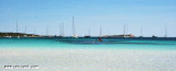
 Coda Cavallo bay, S Capo Coda Cavallo and Proratora islet, affords anchorage, in depths of 10 to 14m, sheltered from all winds excluding Maestrale.
 La baie de Coda Cavallo, au S du cap du même nom et de l'îlot Proratora, offre un mouillage par 10/14 m.
 La baia di Coda Cavallo, S capo Coda Cavallo e dell'isola Proratora, offra un ancoraggio da 10/14 m.