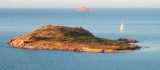
This long peninsula beyond the promontory of Monte Petruso, extending into the Tyrrhenian Sea, has an end portion which is called "Capo Coda Cavallo" ("Queue of horse cape"), because of its curious shape.
This is the extreme point of the marine protected area of Tavolara / Coda Cavallo.
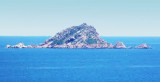
In front of the tip is Proratora island where you can visit a cave.
2012/10/3
Update
Joëlle
Cette longue presqu'île qui, au delà du promontoire de Monte Petruso, s'avance dans la mer Tyrrhénienne, a une partie terminale qui est appelée, en raison de sa forme curieuse, Capo Coda Cavallo ("Cap de la Queue de Cheval").
C'est le point extrême de l'aire maritime protégée de Tavolara/Coda Cavallo.
En face de la pointe se trouve l'îlot Proratora où l'on peut visiter une grotte.
2012/10/3
Update
Joëlle
Questa lunga penisola, che al di là del promontorio di Monte Petruso, si protende nel Mar Tirreno, presenta una porzione terminale che si chiama, per la sua forma curiosa, Capo Coda Cavallo.
Questo è il punto estremo della zona marina protetta di Tavolara / Coda Cavallo.
Di fronte alla punta è Proratora isola dove si può visitare una grotta.
Tavolara island is a limestone massif 6 kilometres long and 500 m wide, and 565 m high.The overhanging cliffs make it inaccessible, with the exception of a bay and a beach that is located at each end of the island, Spalmatore di Fuori northeast (military zone) and Spalmatore di Terra ...
Isola Molara, private island, S Tavolara island, 158m high, is undulating and partially cultivated.The coasts are high and rocky at E (Punta Levante et Punta di Sirocco), they are more practicable with the few beaches and coves located in NW (Cala Cala Chiesa e Spagnola).We see a ...
Degli Aranci gulf is is bounded, on the N, by the peninsula of which Capo Figari is the E extremity.This gulf is sheltered from NE and NW winds. Strong SE winds send in a heavy sea and storms from the N and E cause a considerable swell in the gulf. During offshore winds, which are ...
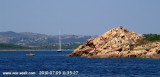
A 15 NM E Molara Island, Molarotto island (51 m) is conical and reddish because it consists of granite. This is the ultimate outpost of land before the open sea.
Cervi rocks, or Three Brothers'rocks, extend between Molara and Molarotto.


 This long peninsula beyond the promontory of Monte Petruso, extending into the Tyrrhenian Sea, has an end portion which is called "Capo Coda Cavallo" ("Queue of horse cape"), because of its curious shape.
 Cette longue presqu'île qui, au delà du promontoire de Monte Petruso, s'avance dans la mer Tyrrhénienne, a une partie terminale qui est appelée, en raison de sa forme curieuse, Capo Coda Cavallo ("Cap de la Queue de Cheval").
 Questa lunga penisola, che al di là del promontorio di Monte Petruso, si protende nel Mar Tirreno, presenta una porzione terminale che si chiama, per la sua forma curiosa, Capo Coda Cavallo.
")
")