Degli Aranci gulf is is bounded, on the N, by the peninsula of which Capo Figari is the E extremity.
This gulf is sheltered from NE and NW winds. Strong SE winds send in a heavy sea and storms from the N and E cause a considerable swell in the gulf. During offshore winds, which are prevalent in winter, the water level in the gulf may be lowered.
The bottom is mostly mud and weed with good holding ground.
The Aranci Gulf harbour is very busy due to its geographical position (it is closer to the peninsula).
The Gulf has another shelter for yachts with its bay Caddinas marina.
2012/09/28
Update
Joëlle
Golfo degli Aranci (Sardegna)
2012-09-28
Update
Joëlle
Le golfe degli Aranci est délimité, au N, par la presqu'île du cap Figari, situé à son extrémité E.
Ce golfe est protégé des vents du NE et du NW. Les forts vents de SE génèrent une mer forte et les tempêtes venant du N et de l'E provoquent une houle considérable dans le golfe. Pendant la période des vents du large, qui sont dominants en hiver, le niveau de l'eau dans le golfe peut baisser.
Le fond, mélange de boue et d'algues, est de bonne tenue.
Le port du golfe Aranci est très fréquenté grâce à sa position géographique (c'est le plus proche de la presqu'île).
Le golfe offre un autre abri aux plaisanciers avec son port de plaisance de la baie de Caddinas.
2012/09/28
Update
Joëlle
Golfo degli Aranci è delimitata a N dalla penisola di Capo Figari, che si trova alla fine E.
Questo golfo è protetto dai venti da NE e NW. I forti venti SE generano mari agitati e le tempeste del N e E causano un rigonfiamento notevole nel Golfo. Durante il periodo di venti di largo, che sono dominanti in inverno, il livello dell'acqua nel Golfo può diminuire.
Il fondo del mare, fango e alghe, è di buona condotta.
Il porto di Golfo Aranci è uno dei più trafficati scali marittimi grazie alla particolare esposizione geografica (è il più vicino alla penisola).
Il Golfo offre un altro rifugio per i naviganti con il suo porto turistico di baia Caddinas.
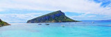
Tavolara island is a limestone massif 6 kilometres long and 500 m wide, and 565 m high.The overhanging cliffs make it inaccessible, with the exception of a bay and a beach that is located at each end of the island, Spalmatore di Fuori northeast (military zone) and Spalmatore di Terra ...
This gulf is S Cugnana gulf, S cala della Volpe. It is entered between Punta della Volpe and Punta Canigione.This gulf is the most protected area of the coast. Although the anchorage is prohibited in the Gulf because of submarine telegraph cables, many boaters anchor in this ...
Gulf of Arzachena (Arsachena), located between Punta Saline and Tre Monti Cape, is a high inlet whose banks are lined with shoals. S tip, Arzachena, W of the entrance, a beacon consists of an iron post with a sheer spherical white marks a rock particularly ...
It is the largest island of the archipelago composed of sixty islets and 7 major islands, in the NE end tip of Sardinia. It is mountainous and arid. This is the only inhabited island thoroughly. It is connected by a bridge to Caprera island where are the house and the tomb of Garibaldi. ...
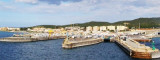
Porto di Golfo Aranci lies at the E head of the gulf and is mainly used by ferries. The harbor consists of two basins, divided by moles. The most remarkable buildings are the post yellowish, the rooting of the median, and E of the village, a house yellow and blue with two ...


 Degli Aranci gulf is is bounded, on the N, by the peninsula of which Capo Figari is the E extremity.
")
 Le golfe degli Aranci est délimité, au N, par la presqu'île du cap Figari, situé à son extrémité E.
 Golfo degli Aranci è delimitata a N dalla penisola di Capo Figari, che si trova alla fine E.