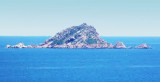
Isola Molara, private island, S Tavolara island, 158m high, is undulating and partially cultivated.
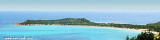
The coasts are high and rocky at E (Punta Levante et Punta di Sirocco), they are more practicable with the few beaches and coves located in NW (Cala Cala Chiesa e Spagnola).
We see a white pillar on its tip E.
Its coasts are unhealthy.
2012/10/3
Update
Joëlle
L'île privée de Molara, au S de Tavolara, est plus basse que l'île Tavolara, elle est ondulée et partiellement cultivée.
Les côtes rocheuses et élevées sont à l'E (Punta Levante et Punta di Sirocco), elles sont plus praticables avec les quelques plages et criques, situées au NW (Cala Spagnola e Cala Chiesa).
On voit un pilier blanc sur sa pointe E.
Ses côtes sont malsaines.
2012/10/3
Update
Joëlle
L'isola privata di Molara, a S di Tavolara, ha una costa prevalentemente rocciosa con piccole cale immerse in un mare particolarmente trasparente.
Le coste alte e rocciose sono nella parte orientale (Punta di Levante e
Punta di Scirocco) e è più praticabile con alcune spiaggette in insenature, sul lato nord-occidentale (Cala
Spagnola e Cala Chiesa).
Vediamo un pilastro bianco sulla punta E.
Le sue coste sono malsani.
2012/10/3
Update
Joëlle
Isola Molara (Sardegna)
L'île Molara et, au fond, Molarotto
2012-10-03
Update
Joëlle
Isola Molara (Sardegna)
Cala Girgolu ou zone de la "Piscine" entre Molara et la côte sarde
Tavolara island is a limestone massif 6 kilometres long and 500 m wide, and 565 m high.The overhanging cliffs make it inaccessible, with the exception of a bay and a beach that is located at each end of the island, Spalmatore di Fuori northeast (military zone) and Spalmatore di Terra ...
Degli Aranci gulf is is bounded, on the N, by the peninsula of which Capo Figari is the E extremity.This gulf is sheltered from NE and NW winds. Strong SE winds send in a heavy sea and storms from the N and E cause a considerable swell in the gulf. During offshore winds, which are ...
A 15 NM E Molara Island, Molarotto island (51 m) is conical and reddish because it consists of granite. This is the ultimate outpost of land before the open sea.
Cervi rocks, or Three Brothers'rocks, extend between Molara and Molarotto.
This long peninsula beyond the promontory of Monte Petruso, extending into the Tyrrhenian Sea, has an end portion which is called "Capo Coda Cavallo" ("Queue of horse cape"), because of its curious shape.
This is the extreme point of the marine protected area of Tavolara / ...


 Isola Molara, private island, S Tavolara island, 158m high, is undulating and partially cultivated.
 L'île privée de Molara, au S de Tavolara, est plus basse que l'île Tavolara, elle est ondulée et partiellement cultivée.
 L'isola privata di Molara, a S di Tavolara, ha una costa prevalentemente rocciosa con piccole cale immerse in un mare particolarmente trasparente.
")
")