Tanjung Jamboaye (Jambuair) (N Sumatra)

Tanjung Jamboaye (Jambuair) (N Sumatra)

To precisely geolocate this site. Update if necessary.

Localisation

Tanjung Jamboaye (Jambuair) (N Sumatra)
LatitudeLongitude
DMS------
DM------
DD------

Characteristics

Lighthouse

Description

Tanjung Jambuair (Diamond Point) consists of a sandy point, just above water, which is marked by some casuarina trees. The coast in the vicinity appears to be receding to the W.

On the cape a 44 m skeletal tower on an octagonal base, is located about 0,5 miles WSW of the point. It's a  Lighthouse painted white. This lighthouse is on Sumatra's northern "shoulder," marking the south side of the entrance to the Strait of Malacca. Located on Tanjung (cape) Jambuair, about 40 km east of Lhokseurnawe.

A white framework water tower stands on the W bank of Tangung Jambuair, about 1 mile SW of the light.

A spit, with depths of less than 5m, extends about 2.7 miles NW from the point and is fairly steep-to on its NE side, over which the sea breaks in places. Discolored water has been reported about 2 miles N of the lighthouse and vessels are advised not to approach in depths of less than 20m especially during the Northwest Monsoon, when there is a heavy swell.

Tides—Currents

The tidal currents set SE and NW. The NW set, being increased by the prevailing NW current, is stronger and of longer duration than the SE set. At springs the current sometimes attains a rate of 3 knots, but in the offing it seldom exceeds l.5 knots.
The tidal currents are weak near the coast W of Tanjung Jambuair.

2012/01/21
Update
Jojo
Ebook

Andaman sea

  • 178 sites
  • 164 photos
  • publication date: 7 Jul 2023
  • .pdf file size: 54 Mb
Share your comments or photos on "Tanjung Jamboaye (Jambuair) (N Sumatra)"

Sites around Tanjung Jamboaye (Jambuair) (N Sumatra)

Flying distances - Direct line

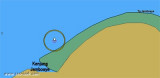
Krueng Jambuair (Djambo Aje) (N Sumatra)

0.2nm
223°
Krueng Jambuair (Djambo Aje or Jamboaye) flows into the sea about 1 mile WSW of Tanjung Jambuair.
The sea usually breaks over the bar at LW, with discolored water from the river sometimes extending as much as 4 miles from the mouth.
21 Jan 12
Jojo

Karang Tengah (N Sumatra)

7.9nm
290°
Tengah, a coral reef, has a least depth of 7.5m and depths from 21.9 to 25.6m around it. The reef lies 5 miles offshore, with Tanjung Jambuair bearing 100°, distance 7.3 miles. Minyak, a 16.5m patch, lies 2 mile NNW of Tengah.
21 Jan 12
Jojo

Ujung Curam (NE Sumatra)

12nm
129°
Ujung Curam (Steile Hoek) is a point that has been reported to be radar conspicuous. A tall chimney, marked by obstruction lights, stands about 8 miles SSW of the point.
Between Tanjung Jambuair and Ujung Curam, 12 miles SE, there are several rivers and creeks.
A sandy mud bank, ...
21 Jan 12
Jojo

Ug Hagu (N Sumatra)

20nm
261°
Ug Hagu consist of a single quay with a length of 20m, a width of 5m, and a depth alongside of 7m. Vessels are restricted from berthing during night time at Lhokseumawe/Ug Hago Wharf or Blanglancang SBM/MBM. Blanglancang Harbor is open for 24 hour service.
21 Jan 12
Jojo

Blanglancang Harbor (N Sumatra)

22nm
266°
Arun Marine Terminal is situated at Blanglancang Harbor.
In the approach to Blanglancang Terminal there are eight prominent storage tanks. About 0.8 mile to the SW of the terminal there are four conspicuous flares.The refinery is serviced by two offshore mooring areas, as well ...
21 Jan 12
Jojo

Old Lhokseumawe Harbor (N Sumatra)

20nm
256°
Old Lhokseumawe Harbor has a small pier 60m long, with a 2.4m depth alongside. Only barges and small vessels under 500 dwt can berth there.
Old Lhokseumawe Harbor can be readily identified by a ridge of hills, 152m high, clear of trees and grass covered.Channel depth in LHOKSEUMAWE ...
21 Jan 12
Jojo