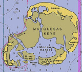
A large shoal, the W part of which is known as The Quicksands, extends 18 miles W from the Marquesas Keys. The shoal is about 4.5 miles wide between the 18-foot curves and has a least depth of 2 feet over its E part. A strong E to W current is observed in the area of The Quicksands.
2012/04/8
Update
Cham
Les Quicksands sont un grand banc, à l'W des Marchesas Keys, qui s'étend sur 18 M. Le banc fait environ 4,5 M de large et a moins de 0,6 m de profondeur dans sa partie E. Un fort courant d'E à W est observé dans la zone des Quicksands.
The Marquesas Keys (not to be confused with the Marquesas Islands (French Polynesia in the Pacific Ocean) form an uninhabited island group about 30 miles (50 km) west of Key West, 4 miles (6 km) in diameter, and overgrown by mangrove. They are protected as part of the Key ...
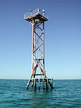
Rebecca Shoal, 43 miles W of Key West, is a small coral bank covered 11 feet. Rebecca Shoal Light (24°34'42"N., 82°35'06"W.), 66 feet above the water, is shown from a square skeleton tower on a brown pile foundation on the S edge of the shoal. A red sector ...
Rebecca Shoal Channel, immediately W of Rebecca Shoal Light, frequently is used by vessels bound from the Straits of Florida to points on the W coast of Florida. Vessels bound for Mobile and points W pass to the W of Dry Tortugas. So far as known, Rebecca Shoal Channel is clear, ...
Southeast Channel skirts the reefs S of East Key and Middle Key, and passes between the 25-foot shoal S of Hospital Key and Iowa Rock off Bush Key Shoal. Iowa Rock is marked by a light. The reefs S of Middle Key can be cleared by keeping S of a line through the abandoned lighthouse ...
Pulaski Shoal, at the NE end of the group, is 12 miles NW of Rebecca Shoal. Pulaski Shoal Light (24°41'36.0"N., 82°46'22.7"W.), 56 feet above the water, is shown from a small black house on a hexagonal pyramidal skeleton tower on piles on the E side of the shoal.The keys are low ...


 A large shoal, the W part of which is known as The Quicksands, extends 18 miles W from the Marquesas
 Les Quicksands sont un grand banc, à l'W des Marchesas Keys, qui s'étend sur 18 M.