Halfmoon Shoal, covered 8 feet, is off the W end of The Quicksands. A wreck covered 6 feet and marked by a light is on the W edge of the shoal.
2012/04/8
Update
Cham
Halfmoon Shoal, couvert de 2,4 m d'eau, est situé à l'extrémité W des Quicksands. Une épave sous 1,8 m d'eau et indiquée par un feu,se trouve sur le bord W du banc.
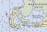
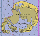
The Marquesas Keys (not to be confused with the Marquesas Islands (French Polynesia in the Pacific Ocean) form an uninhabited island group about 30 miles (50 km) west of Key West, 4 miles (6 km) in diameter, and overgrown by mangrove. They are protected as part of the Key ...
Rebecca Shoal, 43 miles W of Key West, is a small coral bank covered 11 feet. Rebecca Shoal Light (24°34'42"N., 82°35'06"W.), 66 feet above the water, is shown from a square skeleton tower on a brown pile foundation on the S edge of the shoal. A red sector ...
A large shoal, the W part of which is known as The Quicksands, extends 18 miles W from the Marquesas Keys. The shoal is about 4.5 miles wide between the 18-foot curves and has a least depth of 2 feet over its E part. A strong E to W current is observed in the area of The Quicksands.
New Ground, a shoal with a least depth of 4 feet at its W end, is about 6 miles long. It extends in an E-W direction about 3.5 miles N of The Quicksands. A light is on the W side of the 4-foot spot. The water shoals abruptly on the N side of New Ground, and vessels should stay ...
Rebecca Shoal Channel, immediately W of Rebecca Shoal Light, frequently is used by vessels bound from the Straits of Florida to points on the W coast of Florida. Vessels bound for Mobile and points W pass to the W of Dry Tortugas. So far as known, Rebecca Shoal Channel is clear, ...
Mooney Harbor Key is located only about nine miles from Boca Grand. After carefully picking your way around the island you'll find a great outside anchorage on the west side of the island. This anchorage, with water depths of around 10 feet almost to the shore can be found at 24°33.826'N ...


 Halfmoon Shoal, covered 8 feet, is off the W end of The Quicksands. A wreck covered 6 feet and marked by a light is on the W edge of the shoal.
 Halfmoon Shoal, couvert de 2,4 m d'eau, est situé à l'extrémité W des Quicksands. Une épave sous 1,8 m d'eau et indiquée par un feu,se trouve sur le bord W du banc.