Rebecca Shoal Channel, immediately W of Rebecca Shoal Light, frequently is used by vessels bound from the Straits of Florida to points on the W coast of Florida. Vessels bound for Mobile and points W pass to the W of Dry Tortugas.
So far as known, Rebecca Shoal Channel is clear, but possibly there are undiscovered spots with lesser depths than those now charted. Deep-draft vessels should use the passage with great caution, and should continue about 15 miles past the lighted bell buoy marking the 28-foot shoal S of The Quicksands before turning N. The passage is well marked by lights.
In February 1980, a sunken wreck was reported about 7 miles W of Rebecca Shoal Light, in about 24°33.6'N., 82°42.6'W.
2012/04/8
Update
Cham
Rebecca Shoal, immédiatement à l'W du feu de Rebecca Shoal, est fréquemment utilisé par les vaisseaux venant du détroit de Floride pour se rendre sur la côte W de Floride. Les vaisseaux en provenance de Mobile et se rendant à la passe W pour aller à l'W des Dry Tortugas. Rebecca Shoal est clair, mais peut être y a t-il des endroits non connus avec moins de profondeur que celles qui sont indiquées sur les cartes. Les vaisseaux avec un grand TE doivent emprunter le passage avec précaution, et doivent continuer environ 15 M une fois passée la bouée lumineuse indiquant le banc S à 8,4 m de Quicksand avant de tourner au N. Le passage est bien balisé par des bouées lumineuses.
En février 1980, une épave immergée fut signalée à environ 7 M à l'W du feu de Rebecca Shoal, à environ 24°33.6'N., 82°42.6'W.
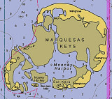
The Marquesas Keys (not to be confused with the Marquesas Islands (French Polynesia in the Pacific Ocean) form an uninhabited island group about 30 miles (50 km) west of Key West, 4 miles (6 km) in diameter, and overgrown by mangrove. They are protected as part of the Key ...
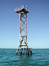
Pulaski Shoal, at the NE end of the group, is 12 miles NW of Rebecca Shoal. Pulaski Shoal Light (24°41'36.0"N., 82°46'22.7"W.), 56 feet above the water, is shown from a small black house on a hexagonal pyramidal skeleton tower on piles on the E side of the shoal.The keys are low ...
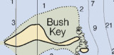
Southeast Channel skirts the reefs S of East Key and Middle Key, and passes between the 25-foot shoal S of Hospital Key and Iowa Rock off Bush Key Shoal. Iowa Rock is marked by a light. The reefs S of Middle Key can be cleared by keeping S of a line through the abandoned lighthouse ...
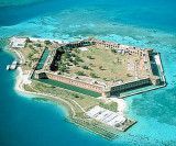
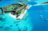
Garden Key is the site of historic Fort Jefferson National Monument, a hexagonal structure with walls 425 feet long rising from a surrounding moat. In 1846, the US Army began to construct a massive fortification on the tiny island known as Garden Key. Sixteen million bricks were ...
the best shelter is SW of Garden Key and the channel encircling it, where protection is afforded from NW winds. However, the holding ground is poor, as boats drag anchor along the silty bottom. Anchorage overnight is allowed in this area.


 Rebecca Shoal Channel, immediately W of Rebecca Shoal Light, frequently is used by vessels bound from the Straits of Florida to points on the W coast of Florida. Vessels bound for Mobile and points W pass to the W of Dry Tortugas.
 Rebecca Shoal, immédiatement à l'W du feu de Rebecca Shoal, est fréquemment utilisé par les vaisseaux venant du détroit de Floride pour se rendre sur la côte W de Floride. Les vaisseaux en provenance de Mobile et se rendant à la passe W pour aller à l'W des Dry Tortugas.