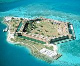
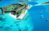
Bird Key Harbor anchorage (Dry Tortugas) (Florida)
4.9nm
358°
The entrance to Bird Key Harbor is narrow, and care is required to avoid the shoals on either side.
The main entrance channel is marked by daybeacons.
8 Apr 12
India
| Latitude | Longitude | |
| DMS | --- | --- |
| DM | --- | --- |
| DD | --- | --- |

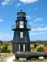
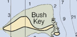
 Southeast Channel skirts the reefs S of East Key and Middle Key, and passes between the 25-foot shoal S of Hospital Key and Iowa Rock off Bush Key Shoal. Iowa Rock is marked by a light.
The current floods N and the ebb S at an average velocity at strength of 0.6 knot.
 Le canal SE longe les rochers S de East Key et Middle Key, et passe entre le S du banc de 7,5 m de Hospital Key et à l'extérieur de Iowa Rock et Bush Key Shoal. Iowa Rock est signalé par un feu.
Le courant des flux N et reflux S ont une vitesse moyenne de 0,6 n?uds.
Ebook | Gulf of Mexico
|