Pulaski Shoal, at the NE end of the group, is 12 miles NW of Rebecca Shoal. Pulaski Shoal Light (24°41'36.0"N., 82°46'22.7"W.), 56 feet above the water, is shown from a small black house on a hexagonal pyramidal skeleton tower on piles on the E side of the shoal.
The keys are low and irregular, and have a thin growth of mangrove. In general, they rise abruptly from deep water and have fairly good channels between them. They are continually changing in size and shape.
2012/04/8
Update
Cham
Pulaski Shoal, au N des Dry Tortugas, se trouve à 12 M au NW de Rebecca Shoal. Le feu de Pulaski Shoal (24°41'36.0"N., 82°46'22.7"W.),à 16,8 m au dessus de l'eau, est porté par une tour hexagonale reposant sur une petite maison noire, à l'E du banc.
Les Keys sont basses et irrégulières et sont constituées de fines pousses de mangrove. En général, elles surgissent brusquement de l'eau profonde et sont bordées de bons canaux entre elles. Elles changent continuellement de taille et de forme.
2012/04/8
Update
Cham
Share your comments or photos on "Pulaski Shoal (Dry Tortugas) (Florida)"
Sites around Pulaski Shoal (Dry Tortugas) (Florida)
Rebecca Shoal Channel, immediately W of Rebecca Shoal Light, frequently is used by vessels bound from the Straits of Florida to points on the W coast of Florida. Vessels bound for Mobile and points W pass to the W of Dry Tortugas. So far as known, Rebecca Shoal Channel is clear, ...
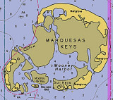
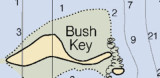
The Marquesas Keys (not to be confused with the Marquesas Islands (French Polynesia in the Pacific Ocean) form an uninhabited island group about 30 miles (50 km) west of Key West, 4 miles (6 km) in diameter, and overgrown by mangrove. They are protected as part of the Key ...
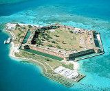
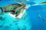
Garden Key is the site of historic Fort Jefferson National Monument, a hexagonal structure with walls 425 feet long rising from a surrounding moat. In 1846, the US Army began to construct a massive fortification on the tiny island known as Garden Key. Sixteen million bricks were ...
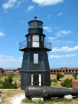
The lighthouse on Garden Key arose in 1826. After the 1873 hurricane, a new lighthouse of iron plate was built atop Fort Jefferson, 70 feet High atop the fortress, marking the harbor entrance until its deactivation in 1924.
the best shelter is SW of Garden Key and the channel encircling it, where protection is afforded from NW winds. However, the holding ground is poor, as boats drag anchor along the silty bottom. Anchorage overnight is allowed in this area.


 (Florida)")
 Pulaski Shoal, at the NE end of the group, is 12 miles NW of Rebecca Shoal. Pulaski Shoal Light (24°41'36.0"N., 82°46'22.7"W.), 56 feet above the water, is shown from a small black house on a hexagonal pyramidal skeleton tower on piles on the E side of the shoal.
 Pulaski Shoal, au N des Dry Tortugas, se trouve à 12 M au NW de Rebecca Shoal. Le feu de Pulaski Shoal (24°41'36.0"N., 82°46'22.7"W.),à 16,8 m au dessus de l'eau, est porté par une tour hexagonale reposant sur une petite maison noire, à l'E du banc.