Secca Mangiabarche (Calasetta S. Antioco Sardegna)
Latitude
Longitude
DMS
---
---
DM
---
---
DD
---
---
Characteristics
Description
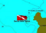
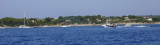
At 8 NM NNW of Sperone cape, at about 1,5 NM of the coast, is the "Mangiabarche" rock marked by a light.
It's a dive site. The place is particularly exposed to winds and currents, so be very careful and dive a day preferably with a time stable.
2012/10/30
Update
A 8 MN au NNW du cap Sperone, à environ 1,5 MN de la côte, le rocher "Mangiabarche" porte une tourelle tronconique lumineuse.
Site de plongée. Le lieu est particulièrement exposé aux vents et aux courants, il faut donc être très prudent et plonger de préférence par une journée avec un temps stable.
2012/10/30
Update
A 8 MN NNW capo Sperone, a circa 1,5 MN dalla costa, lo scoglio "Mangiabarche" ha una torre tronconica luminosa.
E' uno sito di immersione. Il luogo è in una posizione particolarmente esposta ai venti e alle
correnti, per cui bisogna prestare molta attenzione e scegliere una
giornata con tempo stabile.
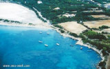
Spiaggia Grande is a wide arc-shaped inlet closed right from Punta Maggiore, where stands an old tuna fishery over the red rocks, and left Punta della Salina.
Anchor in about 3 m in the SW part where the headland provides shelter from the open sea.
After the tip delle Saline is a pond behind the beach, and Delle Saline beach continues to expand with sand dunes covered with abundant vegetation that separates the pond.
This cove is popular with windsurfers who take advantage of the wind blowing offshore.
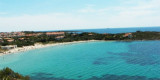
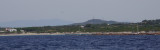
Punta Nera, S Caloforte, so named because of its dark color of its rocks. It is characterized by shallow water and flat land cultivated, dotted with white houses.


 At 8 NM NNW of Sperone cape, at about 1,5 NM of the coast, is the "Mangiabarche" rock marked by a light.
 A 8 MN au NNW du cap Sperone, à environ 1,5 MN de la côte, le rocher "Mangiabarche" porte une tourelle tronconique lumineuse.
 A 8 MN NNW capo Sperone, a circa 1,5 MN dalla costa, lo scoglio "Mangiabarche" ha una torre tronconica luminosa.
")
")
")