Punta Nera, S Caloforte, so named because of its dark color of its rocks. It is characterized by shallow water and flat land cultivated, dotted with white houses.
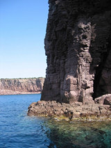
Punta delle Colonne, S end of S. Pietro island. It is is the most southern tip of the island, and it marks the beginning of the rocky part of the island. In fact, although not higher than 20 meters, the walls of rocks fall into the sea with an impressive verticality.
At about 600 m from the shore, it must be very careful at a small shoal barely touches the water and that should keep well offshore. The seabed in this area are low, around 5 m, and fell rapidly to about 25 m.
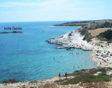
Even the small island of Genia, which emerges near the center of ...
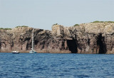
Mezzaluna gulf is between Grossa point and Buemarino point, W of Genia. This beautiful gulf is surrounded by red rocks 30/35 m high. In the fissures of the rocks we can see the entrance of the caves.You can anchor in 12 to 14 m in the middle of the bay.

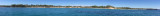


 This small cove is S Punta Nera. It is divided into two parts by a strip of dark rocks.
 Cette anse se trouve au S de Punta Nera. Elle est divisée en deux parties par une petite bande de roches sombres.
 Questa cala si trova S da Punta Nera. E' divisata in due parti da una striscia di scogliera scura.
 ")
")
") Bay largely open to the SE.
Bay largely open to the SE.