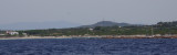
After the tip delle Saline is a pond behind the beach, and Delle Saline beach continues to expand with sand dunes covered with abundant vegetation that separates the pond.
This cove is popular with windsurfers who take advantage of the wind blowing offshore.
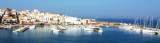
Calasetta commercial port, with low depth, is E of the marina. Visitors can accost at the "B" quay, in 4 m.Beware secca del Francese (2,9 m) N harbour, marked by a N cardinal mark. T. 88930 2 b. visit. (<16 m)Calasetta marina:Outside the commercial port, to W is the Calasetta ...
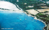
Spiaggia Grande is a wide arc-shaped inlet closed right from Punta Maggiore, where stands an old tuna fishery over the red rocks, and left Punta della Salina.
Anchor in about 3 m in the SW part where the headland provides shelter from the open sea.
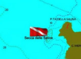
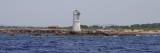
At 8 NM NNW of Sperone cape, at about 1,5 NM of the coast, is the "Mangiabarche" rock marked by a light.It's a dive site. The place is particularly exposed to winds and currents, so be very careful and dive a day preferably with a time stable.


 Sottotorre cove has a beautiful beach, a few meters from the city of Calasetta.
 L'anse de Sottotorre a une belle plage, à quelques mètres de la ville de Calasetta.
 Cala Sottotorre ha una bella spiaggia, vicinissima al paese.
")