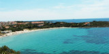
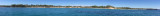
Spiaggia Grande is a wide arc-shaped inlet closed right from Punta Maggiore, where stands an old tuna fishery over the red rocks, and left Punta della Salina.
Anchor in about 3 m in the SW part where the headland provides shelter from the open sea.
2012/10/31
Update
Spiaggia Grande forme un large arc de cercle fermé à droite par Punta Maggiore, où se dresse une vielle "tonnara" sur les rochers rouges, et à gauche par la Punta della Salina.
Le meilleur endroit pour mouiller, par 3 m, se trouve dans la partie SW de l'anse où le promontoire de la "Tonnara" offre un abri du large.
2012/10/31
Update
La spiaggia Grande si presente in un'ampia insenatura a forma di arco chiusa a destra dalla Punta Maggiore, dove si erge una vecchia tonnara sopra le rocce trachitide dal particolare colore rosso, ed a sinistra dalla Punta della Salina.
Ancoraggio, in circa 3 m, nella parte SW dove il promontorio della tonnara offre riparo dal largo.
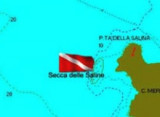
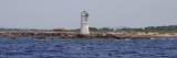
At 8 NM NNW of Sperone cape, at about 1,5 NM of the coast, is the "Mangiabarche" rock marked by a light.It's a dive site. The place is particularly exposed to winds and currents, so be very careful and dive a day preferably with a time stable.
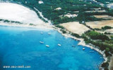
After the tip delle Saline is a pond behind the beach, and Delle Saline beach continues to expand with sand dunes covered with abundant vegetation that separates the pond.
This cove is popular with windsurfers who take advantage of the wind blowing offshore.
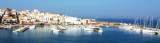
Calasetta commercial port, with low depth, is E of the marina. Visitors can accost at the "B" quay, in 4 m.Beware secca del Francese (2,9 m) N harbour, marked by a N cardinal mark. T. 88930 2 b. visit. (<16 m)Calasetta marina:Outside the commercial port, to W is the Calasetta ...
Punta Nera, S Caloforte, so named because of its dark color of its rocks. It is characterized by shallow water and flat land cultivated, dotted with white houses.


 Spiaggia Grande is a wide arc-shaped inlet closed right from Punta Maggiore, where stands an old tuna fishery over the red rocks, and left Punta della Salina.
 Spiaggia Grande forme un large arc de cercle fermé à droite par Punta Maggiore, où se dresse une vielle "tonnara" sur les rochers rouges, et à gauche par la Punta della Salina.
 La spiaggia Grande si presente in un'ampia insenatura a forma di arco chiusa a destra dalla Punta Maggiore, dove si erge una vecchia tonnara sopra le rocce trachitide dal particolare colore rosso, ed a sinistra dalla Punta della Salina.
")
")