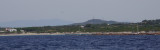
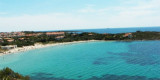
After the tip delle Saline is a pond behind the beach, and Delle Saline beach continues to expand with sand dunes covered with abundant vegetation that separates the pond.
This cove is popular with windsurfers who take advantage of the wind blowing offshore.
Well sheltered from S.
Anchor by 4 m away from the shore.
2012/10/31
Update
Après la pointe delle Saline se trouve un étang derrière la plage, puis la plage delle Saline continue à s'étendre avec des dunes de sable recouvertes d’abondante végétation qui la sépare de l'étang.
Cette anse est très appréciée des windsurfeurs qui profitent du vent qui souffle au large des côtes.
Bon abri des vents du S.
Mouillage par 4 m loin de la rive.
2012/10/31
Update
Dopo la punta delle Saline è uno stagno dietro la spiaggia, e la spiaggia delle Saline continua ad espandersi con dune di sabbia ricoperte di vegetazione abbondante che la separano dallo stagno.
Questa baia è apprezzato dai surfisti che approfittano del vento in mare aperto.
Spiaggia Grande is a wide arc-shaped inlet closed right from Punta Maggiore, where stands an old tuna fishery over the red rocks, and left Punta della Salina.
Anchor in about 3 m in the SW part where the headland provides shelter from the open sea.
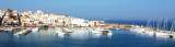
Calasetta commercial port, with low depth, is E of the marina. Visitors can accost at the "B" quay, in 4 m.Beware secca del Francese (2,9 m) N harbour, marked by a N cardinal mark. T. 88930 2 b. visit. (<16 m)Calasetta marina:Outside the commercial port, to W is the Calasetta ...
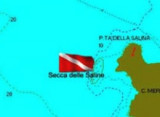
At 8 NM NNW of Sperone cape, at about 1,5 NM of the coast, is the "Mangiabarche" rock marked by a light.It's a dive site. The place is particularly exposed to winds and currents, so be very careful and dive a day preferably with a time stable.


 After the tip delle Saline is a pond behind the beach, and Delle Saline beach continues to expand with sand dunes covered with abundant vegetation that separates the pond.
 Après la pointe delle Saline se trouve un étang derrière la plage, puis la plage delle Saline continue à s'étendre avec des dunes de sable recouvertes d’abondante végétation qui la sépare de l'étang.
 Dopo la punta delle Saline è uno stagno dietro la spiaggia, e la spiaggia delle Saline continua ad espandersi con dune di sabbia ricoperte di vegetazione abbondante che la separano dallo stagno.
")
")