Tavolara island is a limestone massif 6 kilometres long and 500 m wide, and 565 m high.The overhanging cliffs make it inaccessible, with the exception of a bay and a beach that is located at each end of the island, Spalmatore di Fuori northeast (military zone) and Spalmatore di Terra ...
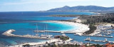
Porto Ottiolu marina is located just SW of Punta di Ottiolu. T. 846211/846213Fax: 846209 Mail: info@marinaportoottiolu.com 405 b. incl. 40 visit. (<18,5 m)
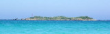
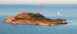
Isolotto d'Ottiolu, low and inconspicuous, lies 1 mile S of Ottiolu cape and is marked by a light. A submerged reef extends about 0.5 mile E of this islet.
Isola Molara, private island, S Tavolara island, 158m high, is undulating and partially cultivated.The coasts are high and rocky at E (Punta Levante et Punta di Sirocco), they are more practicable with the few beaches and coves located in NW (Cala Cala Chiesa e Spagnola).We see a ...
Degli Aranci gulf is is bounded, on the N, by the peninsula of which Capo Figari is the E extremity.This gulf is sheltered from NE and NW winds. Strong SE winds send in a heavy sea and storms from the N and E cause a considerable swell in the gulf. During offshore winds, which are ...
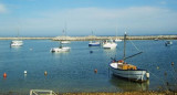
Le port est en phase de construction, il est composé de deux moles qui donnent une protection totale. Mais il n'est pas aménagé à l'intérieur et n'offre aucun service.


 Punta di Ottiolu, located 2.5 miles SE of the village and about 30 km S of Olbia, is sharp and rocky.
 Punta di Ottiolu, située à 2,5 MN au SE du village et à environ 30 km d'Olbia, est étroite et rocheuse.
 Punta di Ottiolu, situata 2,5 MN SE dello villaggio e circa 30 km di Olbia, è tagliente e roccioso.
")