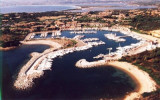
Le port est en phase de construction, il est composé de deux moles qui donnent une protection totale. Mais il n'est pas aménagé à l'intérieur et n'offre aucun service.
2012/10/4
Update
Joëlle
Questo progetto è una buffala.... sono 15 anni che si sta costruendo e ancora un'opera incompiuta.... classico del nostro paese...
Tavolara island is a limestone massif 6 kilometres long and 500 m wide, and 565 m high.The overhanging cliffs make it inaccessible, with the exception of a bay and a beach that is located at each end of the island, Spalmatore di Fuori northeast (military zone) and Spalmatore di Terra ...
Degli Aranci gulf is is bounded, on the N, by the peninsula of which Capo Figari is the E extremity.This gulf is sheltered from NE and NW winds. Strong SE winds send in a heavy sea and storms from the N and E cause a considerable swell in the gulf. During offshore winds, which are ...
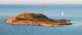
Isola Molara, private island, S Tavolara island, 158m high, is undulating and partially cultivated.The coasts are high and rocky at E (Punta Levante et Punta di Sirocco), they are more practicable with the few beaches and coves located in NW (Cala Cala Chiesa e Spagnola).We see a ...
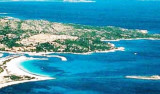
The marina is located around 2,5 NM S capo Coda Cavallo, near Punta Sabbadino that closes the Brandinchi large bay.The Marina, which is in front of the main square with more than 40 shops, is an efficient and smart turistic port. Be carrefull with the rocks, Testa di Moro, at the ...
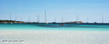
Porto Brandinghi or Brandinchi is a large bay that offers a good anchorage, however, discouraged by E wind raises a big swell. Access to the anchorage by about 8 m, passing between Rossa island (S) and Testa di Moro Rock, triangular and inconspicuous, 0.4 M in S.


 Le port est en phase de construction, il est composé de deux moles qui donnent une protection totale. Mais il n'est pas aménagé à l'intérieur et n'offre aucun service.
 Questo progetto è una buffala.... sono 15 anni che si sta costruendo e ancora un'opera incompiuta.... classico del nostro paese...
")
")