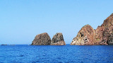
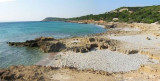
Punta Menga (or Punta Candiani) is located W Porto Pino. It is covered with low végétation and is 31 m high.
The tip is known locally as Candiani. The name comes from the anti-aircraft battery-called anti-ship, of Admiral Camillo Candiani, located on Punta Menga.
2012/10/26
Update
Joëlle
Punta Menga (ou Punta Candiani) se trouve à l'W de Porto Pino. Elle est recouverte de basse végétation et s'élève à 31 m.
La pointe est connue localement sous le nom de Candiani. Le nom vient de la batterie anti-aérienne dite anti-navire, de l'amiral Candiani Camillo, située sur Punta Menga.
2012/10/26
Update
Joëlle
Punta menga (o Punta Candiani) è all'W da Porto Pino. E' coperta di una vegetazione bassa ed è alta di 31 m.
Il picco è conosciuto localmente come il Candiani. Il nome deriva dalla batteria antiaerea-antinave intitolata all'Ammiraglio Camillo Candiani situata sopra Punta Menga.
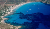
Porto Pino is bordered in its southern part by a rocky coastline with high dunes. N coast is formed instead of a low range. The tip Menga limits Porto Pino W. A lagoon, behind the sand dunes, homes several colonies of flamingos.
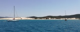
Porto Teulada is a small bay that lies in N Teulada gulf.W bay, Rossa island stands on the coast.Anchorage by 16 m . Beware to shoals tha lie NE of the Niedda point.
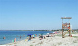
The large bay of Porto Botte is located between the tip of Porto Botte to S and the mouth of the river Palmas to N. It faces the island of Sant 'Antioco. The pond Porto Botte is just behind the beach along the bay.
Must stay away from the beach because the funds back quickly. ...


 Punta Menga (or Punta Candiani) is located W Porto Pino. It is covered with low végétation and is 31 m high.
  Punta Menga (ou Punta Candiani) se trouve à l'W de Porto Pino. Elle est recouverte de basse végétation et s'élève à 31 m.
 Punta menga (o Punta Candiani) è all'W da Porto Pino. E' coperta di una vegetazione bassa ed è alta di 31 m.
")
")
")