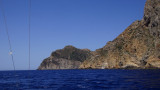
Cala Piombo point has a tower which was built in 1639. It also lies within the polygon Military of Cape Teulada, on a hill 193 m high.
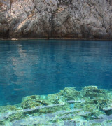
In about1/2 NM of the promontory is a reef (secca di cala Piombo) that rises up to 2 m from the surface and in the past, was responsible of many shipwrecks as shown by the remains found by divers during all these years.
2012/10/25
Update
Joëlle
La pointe de cala Piombo porte une tour qui fut édifiée en 1639. Elle aussi se trouve à l'intérieur du polygone militaire de Cap Teulada, sur un promontoire haut de 193 m.
A environ 1/2 MN du promontoire se trouve un récif (secca di cala Piombo) qui s'élève jusqu'à 2 m de la surface et qui, dans le passé, fut responsable de plusieurs naufrages comme en témoignent les vestiges trouvés par les plongeurs pendant toutes ces années.
2012/10/25
Update
Joëlle
La punta de Cala Piombo ha una torre che fu edificata
intorno al1639. Anch'essa si trova all'interno del poligono militare di Capo Teulada, sopra il promontorio, a 193 m di altezza.
A circa
mezzo miglio dal promontorio viè una secca (secca di cala Piombo) che affiora sino a 2 m dalla superficie, che in passato, è stata la causa di numerosi naufragi, come testimoniano i cimeli rinvenuti dai sub in tutti questi anni.
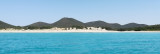
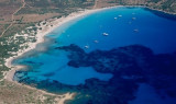
Cala Piombo is a large bay that lies between Punta della cala Piombo to Punta Aligusta. It is well sheltered to S and SE winds. It is lined by a small beach on the SE side.Better not anchor here with strong north-westerly wind (Mistral) because
it has the tendency to turn and come ...
This small cove called also Cala Brigantina, is located inside the shooting zone of Teulada cape where it is strictly to anchor.
Like Cala Piombo, here anchorage is allowed usually from 20th of June and the 20th of September. Strictly forbidden the rest of the year. Usually an ...
This tower is located on the high promontory of Punta della Torre, to E of Porto Zafferano. The tower of Porto Scudo is part of a system of coastal towers that were built by the Aragonese in the sixteenth century on the headlands of the coast of southern Sardinia to spot pirates.
Cala d'Aligusta is between Teulada cape and d'Aligusta point, to W side of cape. It is inside the military polygon of Teulada cape. It is a very small cove, very open to W winds. The small pebble beach is full of fragments brought by the storms.La cala d'Aligastro has a cave that ...
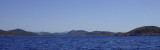
Capo Teulada is forms the southern tip of Sardinia. It is a rocky cliff, 223 m high, which ends at S a peninsula whose slope gradually at N and decreases to the low sandy isthmus that connects the coast. The entire Cape Teulada is, from the fifties, a military firing. Military ...


 Cala Piombo point has a tower which was built in 1639. It also lies within the polygon Military of Cape Teulada, on a hill 193 m high.
 La pointe de cala Piombo porte une tour qui fut édifiée en 1639. Elle aussi se trouve à l'intérieur du polygone militaire de Cap Teulada, sur un promontoire haut de 193 m.
 La punta de Cala Piombo ha una torre che fu edificata
intorno al1639. Anch'essa si trova all'interno del poligono militare di Capo Teulada, sopra il promontorio, a 193 m di altezza.
La punta de Cala Piombo ha una torre che fu edificata
intorno al1639. Anch'essa si trova all'interno del poligono militare di Capo Teulada, sopra il promontorio, a 193 m di altezza.")
")
")
")