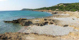
Porto Pino is bordered in its southern part by a rocky coastline with high dunes. N coast is formed instead of a low range. The tip Menga limits Porto Pino W. A lagoon, behind the sand dunes, homes several colonies of flamingos.
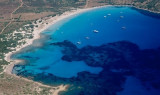
This huge sandy bay provides anchorage without any problem at all depths, far enough from the beach as the background goes very slowly.
2012/10/26
Update
Joëlle
Porto Pino est bordé dans sa partie méridionale par une côte rocheuse avec de hautes dunes. La côte N est au contraire formée d'une plage basse. La pointe Menga limite Porto Pino à l'W. Une lagune, derrière les dunes de sable, abrite plusieurs colonies de flamants roses.
Cette immense baie de sable offre un mouillage sans aucun problème, à toutes les profondeurs, assez loin de la plage car le fond remonte très lentement.
2012/10/26
Update
Joëlle
Porto Pino è delimitato nella sua parte meridionale, da una costa rocciosa con alte dune. N costa è formata invece di una piaggia bassa. Punta Menga termine all'W Porto Pino. Una laguna dietro le dune di sabbia, è il sede di numerose colonie di fenicotteri.
Questo enorme baia sabbiosa fornisce ancoraggio senza problemi a tutte le profondità, abbastanza lontano dalla spiaggia come sfondo va molto lentamente.
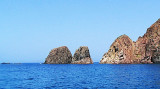
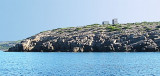
Punta Menga (or Punta Candiani) is located W Porto Pino. It is covered with low végétation and is 31 m high. The tip is known locally as Candiani. The name comes from the anti-aircraft battery-called anti-ship, of Admiral Camillo Candiani, located on Punta Menga.
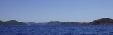
Porto Teulada is a small bay that lies in N Teulada gulf.W bay, Rossa island stands on the coast.Anchorage by 16 m . Beware to shoals tha lie NE of the Niedda point.
Cala Piombo is a large bay that lies between Punta della cala Piombo to Punta Aligusta. It is well sheltered to S and SE winds. It is lined by a small beach on the SE side.Better not anchor here with strong north-westerly wind (Mistral) because
it has the tendency to turn and come ...


 Porto Pino is bordered in its southern part by a rocky coastline with high dunes. N coast is formed instead of a low range. The tip Menga limits Porto Pino W. A lagoon, behind the sand dunes, homes several colonies of flamingos.
 Porto Pino est bordé dans sa partie méridionale par une côte rocheuse avec de hautes dunes. La côte N est au contraire formée d'une plage basse. La pointe Menga limite Porto Pino à l'W. Une lagune, derrière les dunes de sable, abrite plusieurs colonies de flamants roses.
 Porto Pino è delimitato nella sua parte meridionale, da una costa rocciosa con alte dune. N costa è formata invece di una piaggia bassa. Punta Menga termine all'W Porto Pino. Una laguna dietro le dune di sabbia, è il sede di numerose colonie di fenicotteri.
") Sand dunes of Porto Pino.
Sand dunes of Porto Pino.")
") Nice place to moor; sandy beach.
Nice place to moor; sandy beach.