Quartu gulf lies between Foxi tower and S. Elia cape, in the Cagliari Gulf.It is not recommended to anchor in the Quartu bay.Ancorage is also prohibited in a strip between the bearings to 314 ° of Mezza Spiaggia tower and 316 ° to the S. Elia E end cape and extending to 7 NM of shore.
Pula cape is a conical rock connected to the mainland by a sandbar where are few houses and a church. It is the W entry into the Gulf of Cagliari. At W Cape we see some important ruins on the shore of Port of Pula.
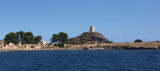
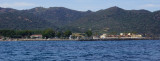
Coltellazzo rock beyond E Pula cape, is dominated by the ...
The marinadi Perd'e Sali, or Porto Combu, is located in the town of Sarroch, about 11 NM S of Cagliari.Caution: The depth at the entrance is less than the significance level. We have 3/5 m in the approach, but the fund decreases rapidly when we are beyond the end of the breakwater, ...


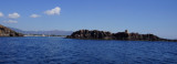
 Porto d'Agumu has an arc shape and is protected from the wind. This is a beautiful bay lined with pines and palm trees.
 Le port d'Agumu a une forme d'arc et est protégé du vent. C'est une jolie baie bordée de pins parasol et de palmiers.
 Il porto di Agumu ha una forma ad arco e è riparata dal vento. E' una bella baia fiancheggiata da pini marittimi e palme.
")
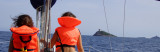
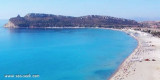
") Nice beach but tout must Anchorage far away as the slope IS low.
Nice beach but tout must Anchorage far away as the slope IS low.") West side of the bay.
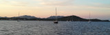
West side of the bay.") Panoramic view of the bay.
Panoramic view of the bay.