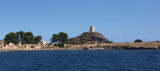

Golfo di Quartu (Sardegna)
12nm
35°
17 Oct 12
Joëlle
| Latitude | Longitude | |
| DMS | --- | --- |
| DM | --- | --- |
| DD | --- | --- |

")
")
 The marinadi Perd'e Sali, or Porto Combu, is located in the town of Sarroch, about 11 NM S of Cagliari.
Caution: The depth at the entrance is less than the significance level. We have 3/5 m in the approach, but the fund decreases rapidly when we are beyond the end of the breakwater, with depths from 1.7 to 1.8 m minimum at the end of the entry.
Once inside, there is very little space for moving between the moorings and pontoons. The marina is full of boats and it may be prudent to call ahead to reserve a spot and learn about depth.
T. +39 0709253145The Marina of Portu Columbu, since several years is not accessible for boats more than m 1.60 deep, because the entrance is obstructed by a sand bank.
 La marina di Perd'e Sali, ou Porto Columbu, se trouve sur la commune de Sarroch, à environ 11 MN au S de Cagliari.
Attention: La profondeur à l'entrée est inférieure à celle portée sur le plan. On a 3-5 m dans l'approche, mais les fonds diminuent rapidement lorsque l'on a dépassé l'extrémité du brise-lames, avec des profondeurs minimum de 1,7-1,8 m au bout de l'entrée.
Une fois à l'intérieur, il y a très peu de place pour manœuvrer entre les amarres et les pontons. La marina est pleine de bateaux à moteur et il peut être sage d'appeler à l'avance pour réserver une place et se renseigner sur la profondeur.
La marina de Porto Columbu, depuis plusieurs années n'est pas accessible aux bateaux de plus de 1,60 m de profondeur, parce que l'entrée est obstruée par un banc de sable.
 Il Porto turistico Perd'e Sali, o Porto Columbu, si trova nel comune di Sarroch, a circa 11 MN a sud di Cagliari.
Attenzione: La profondità all'intrata all'ingresso è inferiore al livello di quello indicato su il piano. Abbiamo 3/5 m nell'approccio, mala profondità diminuisce rapidamente quando abbiamo passato la fine del molo, con 1,7 a 1,8 m di profondità minima alla fine dell'ingresso.
Una volta all'interno, c'è poco spazio di manovra tra gli ormeggi e pontoni. Il porto è pieno di barche e può essere saggio di chiamare in anticipo per prenotare un posto e conoscere la profondità.
Marina Portu Columbu, da diversi anni non è accessibile per le imbarcazioni più di m 1,60 profondità, perché l'ingresso è ostruito da un banco di sabbia.
Ebook | Sardegna South
|
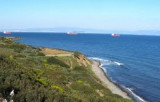
") Port access from the south.
Port access from the south.