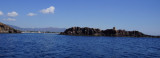
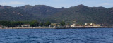
Pula cape is a conical rock connected to the mainland by a sandbar where are few houses and a church. It is the W entry into the Gulf of Cagliari. At W Cape we see some important ruins on the shore of Port of Pula.
Coltellazzo rock beyond E Pula cape, is dominated by the round tower S. Efisio bringing at the top the lantern of a lighthouse.
2013/06/30
Update
dd
Le cap de Pula est un rocher conique relié à la côte par une langue de sable où se trouvent quelques maisons et une église.
C'est l'entrée W dans le golfe de Cagliari. A l'W du cap on voit quelques ruines importantes sur la rive du Port de Pula.
Le rocher Coltellazzo déborde le cap Pula à l'E; Il est dominé par la tour ronde S. Efisio qui porte à son sommet la lanterne d'un phare.
2012/10/19
Update
Joëlle
Il capo di Pula è una roccia conica collegata alla terraferma da una lingua di sabbia dove si trovano alcune case e una chiesa. E' l'ingresso W nel Golfo di Cagliari. All'W del capo si vede alcuni importanti rovine sulla riva del porto di Pula.
La roccia Coltellazzo è situata dopo il capo Pula, all'E; è dominata dalla torre rotonda S. Efisio portando in cima la lanterna di un faro.
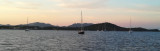
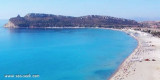
Quartu gulf lies between Foxi tower and S. Elia cape, in the Cagliari Gulf.It is not recommended to anchor in the Quartu bay.Ancorage is also prohibited in a strip between the bearings to 314 ° of Mezza Spiaggia tower and 316 ° to the S. Elia E end cape and extending to 7 NM of shore.
The marinadi Perd'e Sali, or Porto Combu, is located in the town of Sarroch, about 11 NM S of Cagliari.Caution: The depth at the entrance is less than the significance level. We have 3/5 m in the approach, but the fund decreases rapidly when we are beyond the end of the breakwater, ...


") Pula cape
Pula cape") Pula cape and Coltellazzo island.
Pula cape and Coltellazzo island.") Coltellazzo island
Coltellazzo island Pula cape is a conical rock connected to the mainland by a sandbar where are few houses and a church. It is the W entry into the Gulf of Cagliari.
 Le cap de Pula est un rocher conique relié à la côte par une langue de sable où se trouvent quelques maisons et une église.
C'est l'entrée W dans le golfe de Cagliari.
Le cap de Pula est un rocher conique relié à la côte par une langue de sable où se trouvent quelques maisons et une église.
C'est l'entrée W dans le golfe de Cagliari. Il capo di Pula è una roccia conica collegata alla terraferma da una lingua di sabbia dove si trovano alcune case e una chiesa. E' l'ingresso W nel Golfo di Cagliari.
") Capo di Pula
Capo di Pula") View from the west.
View from the west.