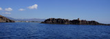
S. Macario tower was builtby the Spaniards in 1595 on the island of St. Macarius at about 400 meters from Punta di Santa Vittoria di Pula. The name comes from the ancient cult that was practiced in the Byzantine monastery dedicated to St. Macarius, whose ruins stand on the western side of the islet.
2012-10-18
Update
Joëlle
Isolotto di S. Macario (Pula Sardegna)
2012-10-18
Update
Joëlle
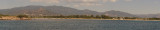
ESE Pula village, 0,4 NM offshore, N S. Macario islet has a tower remakable.
Take notice: never pass between the islet and the mainland because there are submerged rocks difficult to spot.
2013/06/30
Update
dd
Dans l'ESE du village de Pula, à 0,4 MN au large, l'îlot S. Macario porte une tour très visible, au N.
Il ne faut jamais passer entre l'îlot et le continent à cause de la présence de rochers submergés difficiles à repérer.
2012/10/18
Update
Joëlle
All'ESE dal villagio di Pula, 0,4 MN via, l'isolotto S. Macario ha una torre notevole, al N.
Non dovrebbe mai passare tra l'isola e il continente a causa della presenza di rocce sommerse difficili da individuare.
Quartu gulf lies between Foxi tower and S. Elia cape, in the Cagliari Gulf.It is not recommended to anchor in the Quartu bay.Ancorage is also prohibited in a strip between the bearings to 314 ° of Mezza Spiaggia tower and 316 ° to the S. Elia E end cape and extending to 7 NM of shore.
The marinadi Perd'e Sali, or Porto Combu, is located in the town of Sarroch, about 11 NM S of Cagliari.Caution: The depth at the entrance is less than the significance level. We have 3/5 m in the approach, but the fund decreases rapidly when we are beyond the end of the breakwater, ...
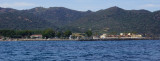
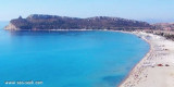
Pula cape is a conical rock connected to the mainland by a sandbar where are few houses and a church. It is the W entry into the Gulf of Cagliari. At W Cape we see some important ruins on the shore of Port of Pula.
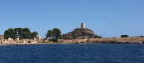
Coltellazzo rock beyond E Pula cape, is dominated by the ...


")
")
 ESE Pula village, 0,4 NM offshore, N S. Macario islet has a tower remakable.
 Dans l'ESE du village de Pula, à 0,4 MN au large, l'îlot S. Macario porte une tour très visible, au N.
 All'ESE dal villagio di Pula, 0,4 MN via, l'isolotto S. Macario ha una torre notevole, al N.
") S. Macario view from NE.
S. Macario view from NE.