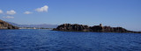
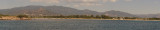
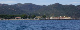
Nora bay, or St Efisio bay, is S bordered by Pula cape and Coltellazzo islet.
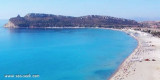
The bay of Nora could be a fine anchorage sheltered by north-westerly winds when not stronger than 20 knots.
We can anchor by 7/20 m.
2012/10/18
Update
Joëlle
Southerly swell enters the bay as it wraps around the headland of Capo di Pula. Very good holding in the NW corner even in strong winds, anchored in 4-5 m. just beware of the reefs along the beach on the Western side of the bay.
2017/07/6
Update
crabblings
La baie de Nora, ou rade de St Efisio, est bordée au S par le cap de Pula et l'îlot Coltellazzo.
La baie peut être un bon mouillage abrité du NW quand il n'est pas plus fort que 20 nœuds.
On mouille par 4/5 m.
2018/07/8
Update
Joëlle
La baia di Nora, o rada di St Efisio, è delimitata da Capo Pula e l'isola Coltellazzo.
La baia puo essere un buon ancoraggio, riparo dal NW quando il vento non è piu forte di 20 nodi.
Quartu gulf lies between Foxi tower and S. Elia cape, in the Cagliari Gulf.It is not recommended to anchor in the Quartu bay.Ancorage is also prohibited in a strip between the bearings to 314 ° of Mezza Spiaggia tower and 316 ° to the S. Elia E end cape and extending to 7 NM of shore.
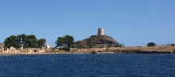
Pula cape is a conical rock connected to the mainland by a sandbar where are few houses and a church. It is the W entry into the Gulf of Cagliari. At W Cape we see some important ruins on the shore of Port of Pula.
Coltellazzo rock beyond E Pula cape, is dominated by the ...
The marinadi Perd'e Sali, or Porto Combu, is located in the town of Sarroch, about 11 NM S of Cagliari.Caution: The depth at the entrance is less than the significance level. We have 3/5 m in the approach, but the fund decreases rapidly when we are beyond the end of the breakwater, ...


 Nora bay, or St Efisio bay, is S bordered by Pula cape and Coltellazzo islet.
 La baie de Nora, ou rade de St Efisio, est bordée au S par le cap de Pula et l'îlot Coltellazzo.
 La baia di Nora, o rada di St Efisio, è delimitata da Capo Pula e l'isola Coltellazzo.
")
") Mooring in the NW of the bay.
Mooring in the NW of the bay.") Baia di Nora
Baia di Nora