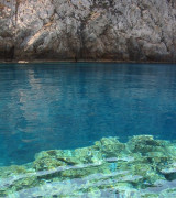
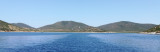
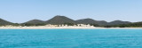
Cala Piombo is a large bay that lies between Punta della cala Piombo to Punta Aligusta. It is well sheltered to S and SE winds. It is lined by a small beach on the SE side.
Better not anchor here with strong north-westerly wind (Mistral) because
it has the tendency to turn and come from west and so entering into the
bay.
Very quiete and safe anchoring site (sand) by 5 m.
Anchorage in a military zone where it is only allowed June 20 to September 21
2012/10/25
Update
Joëlle
Cala Piombo est une grande baie qui s'étend de la pointe de cala Piombo à la pointe Aligusta. Elle très bien protégée des vents de S et SE. Elle est bordée d'une petite plage de sable sur son côté SE.
Mieux vaut ne pas ancrer ici par fort vent de NW (Mistral), car il a tendance à tourner et à arriver dans la baie par l'W.
Mouillage tranquille et protégé, par 5 m.
Cette baie est située en zone militaire, l'ancrage est toléré du 20 juin au 21 septembre.
2012/10/25
Update
Joëlle
Cala Piombo è ampia ben riparata ai venti S e SE. Si estenda tra Punta di Cala Piombo a Punta Aligusta. È fiancheggiata da una piccola spiaggia sul lato SE.
Meglio non ancorare qui con forti venti da NW (maestrale) perché ha la tendenza a girare e provengono da ovest e così entrano nella baia.
Molto quiete e sicuro sito di ancoraggio (sabbia) da 5 m.
Questa baia è in zona militare dovè l'ancoraggio è tollerato da 20 giugno a 21 settembre.
This small cove called also Cala Brigantina, is located inside the shooting zone of Teulada cape where it is strictly to anchor.
Like Cala Piombo, here anchorage is allowed usually from 20th of June and the 20th of September. Strictly forbidden the rest of the year. Usually an ...
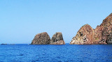
Cala d'Aligusta is between Teulada cape and d'Aligusta point, to W side of cape. It is inside the military polygon of Teulada cape. It is a very small cove, very open to W winds. The small pebble beach is full of fragments brought by the storms.La cala d'Aligastro has a cave that ...
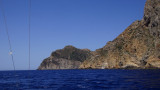
Capo Teulada is forms the southern tip of Sardinia. It is a rocky cliff, 223 m high, which ends at S a peninsula whose slope gradually at N and decreases to the low sandy isthmus that connects the coast. The entire Cape Teulada is, from the fifties, a military firing. Military ...
This tower is located on the high promontory of Punta della Torre, to E of Porto Zafferano. The tower of Porto Scudo is part of a system of coastal towers that were built by the Aragonese in the sixteenth century on the headlands of the coast of southern Sardinia to spot pirates.


 Cala Piombo is a large bay that lies between Punta della cala Piombo to Punta Aligusta. It is well sheltered to S and SE winds. It is lined by a small beach on the SE side.
 Cala Piombo est une grande baie qui s'étend de la pointe de cala Piombo à la pointe Aligusta. Elle très bien protégée des vents de S et SE. Elle est bordée d'une petite plage de sable sur son côté SE.
 Cala Piombo è ampia ben riparata ai venti S e SE. Si estenda tra Punta di Cala Piombo a Punta Aligusta. È fiancheggiata da una piccola spiaggia sul lato SE.
") Cala Piombo
Cala Piombo